Make a donation
Gear up for your next adventure:
As an Amazon Associate, this site earns from qualifying purchases at no extra cost to you.
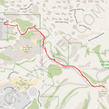
Echo Canyon Trail to Camelback Mountain in Echo Canyon Recreation Area
The trail is strenuous, with steep inclines and a fun rock scramble near the summit, so sturdy footwear and plenty of water are essential. Though challenging, the breathtaking views of Phoenix and the incredible panorama at the top make it a hike worth every step. #Hiking #Mountain #City #Nature
- Distance: 2.3 mi
- Elevation gain: 1,234 ft
- Maximum elevation: 2,615 ft
- Elevation loss: 1,234 ft
- Minimum elevation: 1,447 ft
- Moving time: 1 h 17 m
- Moving speed: 1.8 mph
- Maximum speed: 6.0 mph
- Total time: 1 h 55 m
- Global speed: 1.2 mph
Interactive trail map
Make a donation
Gear up for your next adventure:
As an Amazon Associate, this site earns from qualifying purchases at no extra cost to you.
Trail profile
- Distance: 2.3 mi
- Elevation gain: 1,234 ft
- Maximum elevation: 2,615 ft
- Elevation loss: 1,234 ft
- Minimum elevation: 1,447 ft
- Moving time: 1 h 17 m
- Moving speed: 1.8 mph
- Maximum speed: 6.0 mph
- Total time: 1 h 55 m
- Global speed: 1.2 mph
Make a donation
Gear up for your next adventure:
As an Amazon Associate, this site earns from qualifying purchases at no extra cost to you.
About this trail
Name: Echo Canyon Trail to Camelback Mountain in Echo Canyon Recreation Area trail, distance, elevation, map, profile, GPS track
Coordinates: 33.51468 -111.97381 33.52131 -111.96155
Topography: Phoenix topographic map, elevation, terrain
Make a donation
Gear up for your next adventure:
As an Amazon Associate, this site earns from qualifying purchases at no extra cost to you.
Other hiking, mountain biking, running and outdoor activity trails
Click on a trail to view its statistics, map and profile.
Camelback Mountain via Echo Canyon Trail and Echo Canyon Viewpoint in Echo Canyon Recreation Area
United States > Arizona > Maricopa County > Phoenix
The Echo Canyon Trail on Camelback Mountain offers a rigorous and exhilarating hike, known for its steep ascents and rocky terrain. Along the way, hikers are rewarded with expansive views of Phoenix's skyline, surrounded by rugged desert canyons and scattered saguaro cacti. As you climb, the scenery shifts,…
Distance: 2.7 mi • Elevation gain: 1,398 ft • Maximum elevation: 2,615 ft
Camelback Mountain via Cholla Trail in Echo Canyon Recreation Area
United States > Arizona > Maricopa County > Phoenix
The Cholla Trail to the summit of Camelback Mountain offers a captivating yet demanding hiking experience, with diverse terrain ranging from gentle slopes to challenging rock scrambles as you approach the peak. The trail provides stunning views of the Phoenix cityscape and surrounding desert landscapes,…
Distance: 1.4 mi • Elevation gain: 1,181 ft • Maximum elevation: 2,598 ft