Make a donation
Gear up for your next adventure:
As an Amazon Associate, this site earns from qualifying purchases at no extra cost to you.
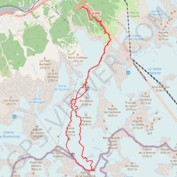
Mont Blanc par les Grands Mulets
- Distance: 15.9 mi
- Elevation gain: 12,572 ft
- Maximum elevation: 15,745 ft
- Elevation loss: 12,566 ft
- Minimum elevation: 4,147 ft
Interactive trail map
Make a donation
Gear up for your next adventure:
As an Amazon Associate, this site earns from qualifying purchases at no extra cost to you.
Trail profile
- Distance: 15.9 mi
- Elevation gain: 12,572 ft
- Maximum elevation: 15,745 ft
- Elevation loss: 12,566 ft
- Minimum elevation: 4,147 ft
Make a donation
Gear up for your next adventure:
As an Amazon Associate, this site earns from qualifying purchases at no extra cost to you.
About this trail
Name: Mont Blanc par les Grands Mulets trail, distance, elevation, map, profile, GPS track
Coordinates: 45.83249 6.84844 45.90077 6.87512
Make a donation
Gear up for your next adventure:
As an Amazon Associate, this site earns from qualifying purchases at no extra cost to you.
Other hiking, mountain biking, running and outdoor activity trails
Click on a trail to view its statistics, map and profile.
Ultra-Trail du Mont Blanc (UTMB)
France > Auvergne-Rhône-Alpes > Upper Savoy > Chamonix-Mont-Blanc
Distance: 104.2 mi • Elevation gain: 34,285 ft • Maximum elevation: 8,317 ft
Монблан
France > Auvergne-Rhône-Alpes > Upper Savoy > Saint-Gervais-les-Bains
Distance: 4.9 mi • Elevation gain: 7,490 ft • Maximum elevation: 15,128 ft
Монблан
France > Auvergne-Rhône-Alpes > Upper Savoy > Saint-Gervais-les-Bains
Distance: 4.9 mi • Elevation gain: 7,490 ft • Maximum elevation: 15,128 ft
TTdMB-1 Tour Du Mont Blanc - Itinéraire Principal
France > Auvergne-Rhône-Alpes > Upper Savoy > Chamonix-Mont-Blanc
Distance: 103.1 mi • Elevation gain: 34,564 ft • Maximum elevation: 8,323 ft
Make a donation
Gear up for your next adventure:
As an Amazon Associate, this site earns from qualifying purchases at no extra cost to you.
UTMB 2020
France > Auvergne-Rhône-Alpes > Upper Savoy > Chamonix-Mont-Blanc > Les Bossons
Total: 171.3km
Distance: 104.5 mi • Elevation gain: 34,534 ft • Maximum elevation: 8,445 ft
PT23DS2 Lörrach → Cadaqués
Germany > Baden-Württemberg > Landkreis Lörrach > Lörrach (Kernstadt)
Distance: 652.9 mi • Elevation gain: 43,077 ft • Maximum elevation: 4,938 ft