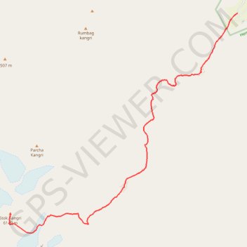
Stok Kangri Peak - Hemis National Park
- Distance: 10.8 mi
- Elevation gain: 8,340 ft
- Maximum elevation: 19,980 ft
- Elevation loss: 230 ft
- Minimum elevation: 11,798 ft
Interactive trail map
Trail profile
- Distance: 10.8 mi
- Elevation gain: 8,340 ft
- Maximum elevation: 19,980 ft
- Elevation loss: 230 ft
- Minimum elevation: 11,798 ft
About this trail
Name: Stok Kangri Peak - Hemis National Park trail, distance, elevation, map, profile, GPS track
Start: Stok, Leh district, Ladakh, India (34.05612 77.53789)
End: Trail to Stok Kangri, Leh district, Ladakh, India (33.98643 77.44221)
Coordinates: 33.97931 77.44172 34.05612 77.53789
Other hiking, mountain biking, running and outdoor activity trails
Click on a trail to view its statistics, map and profile.
Markha Valley - Hemis National Park
Distance: 58.3 mi • Elevation gain: 15,010 ft • Maximum elevation: 17,274 ft