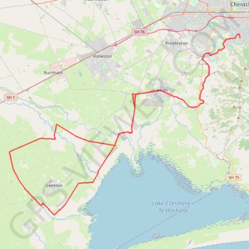
Import a GPX file

South Canterbury

#Bike #Loop

  • Distance: 72.0 mi
  • Elevation gain: 1,024 ft
  • Maximum elevation: 200 ft
  • Elevation loss: 1,007 ft
  • Minimum elevation: 10 ft

Interactive trail map

Trail profile

  • Distance: 72.0 mi
  • Elevation gain: 1,024 ft
  • Maximum elevation: 200 ft
  • Elevation loss: 1,007 ft
  • Minimum elevation: 10 ft

About this trail

Other hiking, mountain biking, running and outdoor activity trails

Click on a trail to view its statistics, map and profile.

Tour Te Waipounamu

New Zealand > Tasman > Tasman District > Port Pūponga

Bikepacking race through the South Island of New Zealand. #Bike #Race #Island #Sea #Pacific #Ocean #Nature #Mountain #Forest #Countryside

Distance: 820.8 mi • Elevation gain: 76,647 ft • Maximum elevation: 6,385 ft

Birdlings Flat Gravel/Unpaved Cycling

New Zealand > Canterbury > Christchurch City > Banks Peninsula Community

Distance: 13.3 mi • Elevation gain: 364 ft • Maximum elevation: 125 ft

Halswell River

New Zealand > Canterbury > Christchurch City > Banks Peninsula Community

Distance: 42.8 mi • Elevation gain: 1,050 ft • Maximum elevation: 131 ft

Gear up for your next adventure:

🥇GPS Hiking Watch - Multi‑sport GPS watch with navigation and trail tracking
🛌Ultralight Sleeping Bags - Compact down bags for cold nights in the wilderness
🏔️Mountain Trail Maps - High‑detail maps for popular peaks
👟Men's Trail Runners - Lightweight footwear for fast-paced exploration and light hiking
🌧️Backpack Rain Cover - Keep gear dry in wet weather

As an Amazon Associate, this site earns from qualifying purchases at no extra cost to you.