Douglas Park
- Distance: 1.4 mi
- Elevation gain: 184 ft
- Maximum elevation: 174 ft
- Elevation loss: 184 ft
- Minimum elevation: 72 ft
- Moving time: 25 m 34 s
- Moving speed: 3.2 mph
- Maximum speed: 6.8 mph
- Total time: 29 m 9 s
- Global speed: 2.8 mph
Interactive trail map
Trail profile
- Distance: 1.4 mi
- Elevation gain: 184 ft
- Maximum elevation: 174 ft
- Elevation loss: 184 ft
- Minimum elevation: 72 ft
- Moving time: 25 m 34 s
- Moving speed: 3.2 mph
- Maximum speed: 6.8 mph
- Total time: 29 m 9 s
- Global speed: 2.8 mph
About this trail
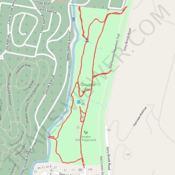
Name: Douglas Park trail, distance, elevation, map, profile, GPS track
Coordinates: 41.09121 -73.85979 41.09613 -73.85660
Topography: Westchester County topographic map, elevation, terrain
Other hiking, mountain biking, running and outdoor activity trails
Click on a trail to view its statistics, map and profile.
Old Croton Aqueduct Trail and Bronx
United States > New York > Westchester County > Village of Croton-on-Hudson
Distance: 44.0 mi • Elevation gain: 2,700 ft • Maximum elevation: 262 ft
Rockefeller State Park trails
United States > New York > Westchester County > Town of Mount Pleasant
Distance: 6.3 mi • Elevation gain: 722 ft • Maximum elevation: 443 ft