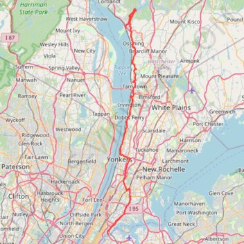
Old Croton Aqueduct Trail and Bronx
- Distance: 44.0 mi
- Elevation gain: 2,700 ft
- Maximum elevation: 262 ft
- Elevation loss: 2,713 ft
- Minimum elevation: 0 ft
- Moving time: 4 h 27 m
- Moving speed: 9.9 mph
- Maximum speed: 31.4 mph
- Total time: 5 h 54 m
- Global speed: 7.4 mph
Interactive trail map
Trail profile
- Distance: 44.0 mi
- Elevation gain: 2,700 ft
- Maximum elevation: 262 ft
- Elevation loss: 2,713 ft
- Minimum elevation: 0 ft
- Moving time: 4 h 27 m
- Moving speed: 9.9 mph
- Maximum speed: 31.4 mph
- Total time: 5 h 54 m
- Global speed: 7.4 mph
About this trail
Name: Old Croton Aqueduct Trail and Bronx trail, distance, elevation, map, profile, GPS track
Coordinates: 40.78075 -73.92972 41.22814 -73.85431
Topography: Westchester County topographic map, elevation, terrain
Other hiking, mountain biking, running and outdoor activity trails
Click on a trail to view its statistics, map and profile.
State Line Lookout, White Shore, Giant Steps and Long Path Loop in Trail in Palisades Interstate Park
United States > New Jersey > Bergen County > Alpine
This loop hike offers an invigorating blend of stunning vistas and diverse terrain. Hikers can enjoy sweeping views of the Hudson River and the New York City skyline, while navigating through a variety of landscapes, including rocky outcrops and serene forest paths. Notable features along the route include the…
Distance: 4.0 mi • Elevation gain: 1,037 ft • Maximum elevation: 545 ft
Long Path and Shore Loop in Palisades Interstate Park
United States > New Jersey > Bergen County > Alpine
This loop hike offers a captivating blend of natural beauty and rugged terrain, featuring panoramic views of the Hudson River and dramatic cliffs. Hikers can encounter diverse landscapes, including rocky descents, lush woodlands, and serene waterfronts, with spots ideal for resting and taking in the…
Distance: 6.1 mi • Elevation gain: 955 ft • Maximum elevation: 554 ft
Giant Stairs Palisades Loop
United States > New Jersey > Bergen County > Alpine
Distance: 4.5 mi • Elevation gain: 1,585 ft • Maximum elevation: 538 ft
Oscawana Park
United States > New York > Westchester County > Town of Cortlandt > Crugers > Oscawana
Distance: 4.8 mi • Elevation gain: 459 ft • Maximum elevation: 151 ft
Palisades Interstate Park Loop
United States > New Jersey > Bergen County > Alpine
Loop hike along the Hudson River via Long Path, Shore Trail, Peanut Leap Cascade, Giant Stairs, Blue and white Trail, State Line Lookout and Border Monument in the Palisades Interstate Park. #Hiking #Loop #River #Nature #Forest #Park #Falls #Overlook
Distance: 4.6 mi • Elevation gain: 1,283 ft • Maximum elevation: 538 ft
Juhring Nature Preserve trails
United States > New York > Westchester County > Village of Dobbs Ferry
Distance: 2.5 mi • Elevation gain: 171 ft • Maximum elevation: 384 ft
Trace of trails at Croton Point Park
United States > New York > Westchester County > Village of Croton-on-Hudson
Distance: 8.0 mi • Elevation gain: 535 ft • Maximum elevation: 115 ft
Rockleigh Woods Sanctuary
United States > New Jersey > Bergen County > Rockleigh
Distance: 6.8 mi • Elevation gain: 1,066 ft • Maximum elevation: 492 ft
Estherwood Trail
United States > New York > Westchester County > Village of Dobbs Ferry
Distance: 2.6 mi • Elevation gain: 348 ft • Maximum elevation: 463 ft
Blauvelt State Park, Buttermilk Falls Park and Schuyler Town Park loop
United States > New York > Rockland County > Blauvelt
Distance: 6.0 mi • Elevation gain: 1,132 ft • Maximum elevation: 627 ft
Mount Nebo to Blauvelt State Park via Long Path Green Trail
United States > New York > Rockland County > Blauvelt
Distance: 11.8 mi • Elevation gain: 1,460 ft • Maximum elevation: 656 ft
Palisades Loop Hike via Shore Trail and Long Path
United States > New Jersey > Bergen County > Alpine
Distance: 5.2 mi • Elevation gain: 909 ft • Maximum elevation: 456 ft
Palisades Interstate Park Mountain Bike Ride
United States > New Jersey > Bergen County > Rockleigh
Distance: 8.5 mi • Elevation gain: 1,083 ft • Maximum elevation: 531 ft
Rail Trail Walk, Blauvelt Orangeburg
United States > New York > Rockland County > Village of Piermont
Distance: 7.9 mi • Elevation gain: 331 ft • Maximum elevation: 197 ft
Peabody Preserve Outdoor Classroom trails
United States > New York > Westchester County > Village of Sleepy Hollow > Philipse Manor
Distance: 1.9 mi • Elevation gain: 131 ft • Maximum elevation: 69 ft
Peanut Leap Hike
United States > New Jersey > Bergen County > Alpine
Distance: 5.0 mi • Elevation gain: 1,266 ft • Maximum elevation: 541 ft
Palisades Interstate Park loop trails
United States > New Jersey > Bergen County > Alpine
Distance: 13.8 mi • Elevation gain: 1,699 ft • Maximum elevation: 561 ft
Clausland Mountain County Park loop
United States > New York > Rockland County > Blauvelt
Distance: 4.1 mi • Elevation gain: 568 ft • Maximum elevation: 656 ft
Crawbuckie Nature Preserve Trails
United States > New York > Westchester County > Village of Ossining > Mariandale
Distance: 2.2 mi • Elevation gain: 305 ft • Maximum elevation: 171 ft
Alpine & Rockleigh E-Biking
United States > New Jersey > Bergen County > Alpine
Distance: 16.2 mi • Elevation gain: 2,215 ft • Maximum elevation: 561 ft
Nebo Clausland Tackamac Blauvelt
United States > New York > Rockland County > Orangeburg
Distance: 11.8 mi • Elevation gain: 1,568 ft • Maximum elevation: 659 ft
Rockefeller State Park trails
United States > New York > Westchester County > Town of Mount Pleasant
Distance: 6.3 mi • Elevation gain: 722 ft • Maximum elevation: 443 ft
Alpine & Rockleigh loop ride
United States > New Jersey > Bergen County > Alpine
Distance: 14.2 mi • Elevation gain: 1,804 ft • Maximum elevation: 561 ft
Blauvelt State Park
United States > New York > Rockland County > Blauvelt
Distance: 11.7 mi • Elevation gain: 1,424 ft • Maximum elevation: 656 ft
Alpine & Rockleigh
United States > New Jersey > Bergen County > Alpine
Palisades Interstate Park.
Distance: 9.3 mi • Elevation gain: 1,014 ft • Maximum elevation: 561 ft
Alpine & Rockleigh
United States > New Jersey > Bergen County > Alpine
Palisades Interstate Park
Distance: 12.6 mi • Elevation gain: 1,759 ft • Maximum elevation: 561 ft
Tibbetts Brook Park
United States > New York > Westchester County > City of Yonkers
Distance: 2.7 mi • Elevation gain: 187 ft • Maximum elevation: 144 ft
Alpine & Rockleigh
United States > New Jersey > Bergen County > Alpine
Distance: 13.1 mi • Elevation gain: 1,726 ft • Maximum elevation: 561 ft
Alpine & Rockleigh
United States > New Jersey > Bergen County > Alpine
Distance: 12.4 mi • Elevation gain: 1,424 ft • Maximum elevation: 561 ft
Rockwood Hall Loop
United States > New York > Westchester County > Town of Mount Pleasant > Sleepy Hollow Manor
Distance: 3.3 mi • Elevation gain: 331 ft • Maximum elevation: 184 ft
Westchester RiverWalk
United States > New York > Westchester County > Village of Tarrytown
Distance: 1.5 mi • Elevation gain: 295 ft • Maximum elevation: 233 ft
Alpine Rockleigh
United States > New Jersey > Bergen County > Alpine
Distance: 14.7 mi • Elevation gain: 1,893 ft • Maximum elevation: 561 ft
To the top of Manhattan
United States > New York > New York County > New York
Distance: 1.6 mi • Elevation gain: 233 ft • Maximum elevation: 207 ft
Morning Run
United States > New York > New York County > New York
Distance: 8.5 mi • Elevation gain: 518 ft • Maximum elevation: 112 ft
Halsey Pond Park
United States > New York > Westchester County > Village of Irvington
Distance: 1.5 mi • Elevation gain: 151 ft • Maximum elevation: 325 ft
Alpine Rockleigh
United States > New Jersey > Bergen County > Alpine
Distance: 15.3 mi • Elevation gain: 2,034 ft • Maximum elevation: 561 ft
Douglas Park
United States > New York > Westchester County > Village of Sleepy Hollow > Philipse Manor
Distance: 1.4 mi • Elevation gain: 184 ft • Maximum elevation: 174 ft
Rockland Lake State Park
United States > New York > Rockland County > Valley Cottage
Distance: 0.7 mi • Elevation gain: 26 ft • Maximum elevation: 167 ft