Make a donation
Gear up for your next adventure:
As an Amazon Associate, this site earns from qualifying purchases at no extra cost to you.
Old Waynesborough Park loop
- Distance: 3.0 mi
- Elevation gain: 49 ft
- Maximum elevation: 75 ft
- Elevation loss: 46 ft
- Minimum elevation: 59 ft
- Moving time: 1 h 21 m
- Moving speed: 2.2 mph
- Maximum speed: 5.1 mph
- Total time: 1 h 45 m
- Global speed: 1.7 mph
Interactive trail map
Make a donation
Gear up for your next adventure:
As an Amazon Associate, this site earns from qualifying purchases at no extra cost to you.
Trail profile
- Distance: 3.0 mi
- Elevation gain: 49 ft
- Maximum elevation: 75 ft
- Elevation loss: 46 ft
- Minimum elevation: 59 ft
- Moving time: 1 h 21 m
- Moving speed: 2.2 mph
- Maximum speed: 5.1 mph
- Total time: 1 h 45 m
- Global speed: 1.7 mph
Make a donation
Gear up for your next adventure:
As an Amazon Associate, this site earns from qualifying purchases at no extra cost to you.
About this trail
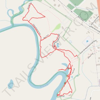
Name: Old Waynesborough Park loop trail, distance, elevation, map, profile, GPS track
Start: 801, Red Trail, Goldsboro, Wayne County, North Carolina, 27530, United States (35.37195 -78.01689)
Coordinates: 35.36844 -78.02375 35.37889 -78.01620
Topography: Goldsboro topographic map, elevation, terrain
Make a donation
Gear up for your next adventure:
As an Amazon Associate, this site earns from qualifying purchases at no extra cost to you.
Other hiking, mountain biking, running and outdoor activity trails
Click on a trail to view its statistics, map and profile.
Old Waynesborough Park Yellow and Orange Loop Trail
United States > North Carolina > Wayne County > Goldsboro
Distance: 2.1 mi • Elevation gain: 33 ft • Maximum elevation: 75 ft
Old Waynesborough Park Loop
United States > North Carolina > Wayne County > Goldsboro
Distance: 1.7 mi • Elevation gain: 36 ft • Maximum elevation: 75 ft
Old Waynesborough Park Red Trail
United States > North Carolina > Wayne County > Goldsboro
Distance: 1.3 mi • Elevation gain: 26 ft • Maximum elevation: 75 ft