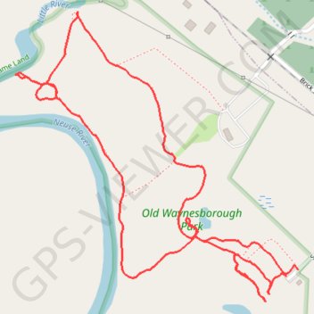
Old Waynesborough Park Yellow and Orange Loop Trail
- Distance: 2.1 mi
- Elevation gain: 33 ft
- Maximum elevation: 75 ft
- Elevation loss: 30 ft
- Minimum elevation: 59 ft
- Moving time: 46 m 27 s
- Moving speed: 2.7 mph
- Maximum speed: 6.4 mph
- Total time: 46 m 27 s
- Global speed: 2.7 mph
Interactive trail map
Trail profile
- Distance: 2.1 mi
- Elevation gain: 33 ft
- Maximum elevation: 75 ft
- Elevation loss: 30 ft
- Minimum elevation: 59 ft
- Moving time: 46 m 27 s
- Moving speed: 2.7 mph
- Maximum speed: 6.4 mph
- Total time: 46 m 27 s
- Global speed: 2.7 mph
About this trail
Name: Old Waynesborough Park Yellow and Orange Loop Trail trail, distance, elevation, map, profile, GPS track
Coordinates: 35.37224 -78.02433 35.37908 -78.01617
Topography: Goldsboro topographic map, elevation, terrain
Other hiking, mountain biking, running and outdoor activity trails
Click on a trail to view its statistics, map and profile.
Old Waynesborough Park loop
United States > North Carolina > Wayne County > Goldsboro
Distance: 3.0 mi • Elevation gain: 49 ft • Maximum elevation: 75 ft
Old Waynesborough Park Loop
United States > North Carolina > Wayne County > Goldsboro
Distance: 1.7 mi • Elevation gain: 36 ft • Maximum elevation: 75 ft
Old Waynesborough Park Red Trail
United States > North Carolina > Wayne County > Goldsboro
Distance: 1.3 mi • Elevation gain: 26 ft • Maximum elevation: 75 ft