Mammoth to Bridgeport
Northern California Backcountry Discovery Route (CABDR-North)
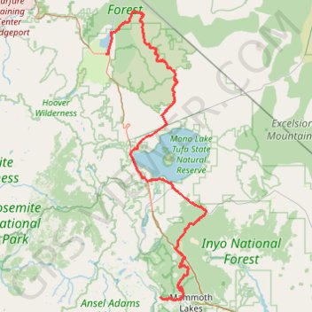
- Distance: 94.8 mi
- Elevation gain: 7,188 ft
- Maximum elevation: 9,259 ft
- Elevation loss: 9,957 ft
- Minimum elevation: 6,414 ft
Interactive trail map
Trail profile
- Distance: 94.8 mi
- Elevation gain: 7,188 ft
- Maximum elevation: 9,259 ft
- Elevation loss: 9,957 ft
- Minimum elevation: 6,414 ft
About this trail
Name: Mammoth to Bridgeport trail, distance, elevation, map, profile, GPS track
End: 453, Main Street, Bridgeport, Mono County, California, 93517, United States (38.25571 -119.23148)
Coordinates: 37.64862 -119.23148 38.35992 -118.91677
Topography: Mono County topographic map, elevation, terrain
Other hiking, mountain biking, running and outdoor activity trails
Click on a trail to view its statistics, map and profile.
Agnew Meadows to Ediza Lake via Shadow Creek Trail, Olaine Lake and Shadow Lake
United States > California > Madera County
The hike to Ediza Lake via the Shadow Creek Trail offers a remarkable journey through the scenic heart of the Ansel Adams Wilderness. As you pass Shadow Lake, you'll witness serene waters framed by towering peaks, while the trail winds through lush forests, cascading streams, and wildflower-filled meadows.…
Distance: 6.8 mi • Elevation gain: 1,519 ft • Maximum elevation: 9,314 ft
Gravel bike ride around Mammoth Lakes
United States > California > Mono County
Distance: 33.8 mi • Elevation gain: 3,406 ft • Maximum elevation: 8,986 ft
Rush Creek Trail
United States > California > Mono County
Distance: 2.1 mi • Elevation gain: 663 ft • Maximum elevation: 7,861 ft