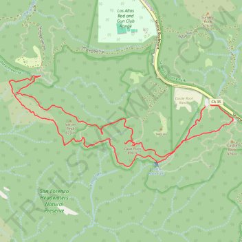
Saratoga Gap and Ridge Trails Loop in Castle Rock State Park
The Saratoga Gap and Ridge Trails Loop in Castle Rock State Park offers hikers a diverse journey through lush forests, interspersed with striking sandstone formations like Goat Rock. As the trail ascends, it unveils panoramic vistas of the San Lorenzo Valley, with distant glimpses of Monterey Bay and the Santa Lucia Range. Notably, the route features Castle Rock Falls, which, during wetter seasons, cascades dramatically over a 70-foot drop, adding a serene soundtrack to the hike. #Hiking #Loop #Forest #Rock #Waterfall #Nature #Overlook
- Distance: 5.0 mi
- Elevation gain: 1,332 ft
- Maximum elevation: 3,054 ft
- Elevation loss: 1,325 ft
- Minimum elevation: 2,290 ft
- Moving time: 2 h 32 m
- Moving speed: 2.0 mph
- Maximum speed: 5.2 mph
- Total time: 3 h 18 m
- Global speed: 1.5 mph
Interactive trail map
Trail profile
- Distance: 5.0 mi
- Elevation gain: 1,332 ft
- Maximum elevation: 3,054 ft
- Elevation loss: 1,325 ft
- Minimum elevation: 2,290 ft
- Moving time: 2 h 32 m
- Moving speed: 2.0 mph
- Maximum speed: 5.2 mph
- Total time: 3 h 18 m
- Global speed: 1.5 mph
About this trail
Name: Saratoga Gap and Ridge Trails Loop in Castle Rock State Park trail, distance, elevation, map, profile, GPS track
Start: Castle Rock Parking, Santa Cruz County, California, United States (37.23186 -122.09929)
End: Skyline Boulevard, Santa Clara County, California, United States (37.23201 -122.09869)
Coordinates: 37.22616 -122.12273 37.23481 -122.09596
Topography: Santa Cruz County topographic map, elevation, terrain
Other hiking, mountain biking, running and outdoor activity trails
Click on a trail to view its statistics, map and profile.
Russel Point Loop via Castle Rock Falls, Emily Smith Observation Point, Goat Rock and Castle Rock
United States > California > Santa Cruz County
The Russell Point Loop at Castle Rock State Park offers a rewarding hike through diverse terrain, with views that include the rugged cliffs of Castle Rock, the cascading Castle Rock Falls, and the sweeping vistas from the Emily Smith Observation Point. As hikers progress, they are treated to panoramic views of…
Distance: 5.4 mi • Elevation gain: 1,532 ft • Maximum elevation: 3,153 ft
Hiking the lower loop at Castle Rock State Park
United States > California > Santa Clara County
Distance: 6.6 mi • Elevation gain: 1,539 ft • Maximum elevation: 3,153 ft