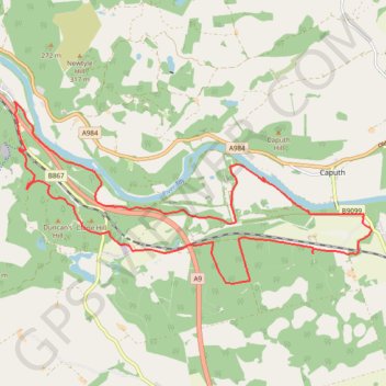
Mountain Bike loop ride around Murthly, Perthshire Scotland
UK, Perthshire, Dunkeld, Murthly
- Distance: 11.2 mi
- Elevation gain: 978 ft
- Maximum elevation: 584 ft
- Elevation loss: 978 ft
- Minimum elevation: 131 ft
- Moving time: 1 h 52 m
- Moving speed: 6.0 mph
- Maximum speed: 19.7 mph
- Total time: 2 h 33 m
- Global speed: 4.4 mph
Interactive trail map
Trail profile
- Distance: 11.2 mi
- Elevation gain: 978 ft
- Maximum elevation: 584 ft
- Elevation loss: 978 ft
- Minimum elevation: 131 ft
- Moving time: 1 h 52 m
- Moving speed: 6.0 mph
- Maximum speed: 19.7 mph
- Total time: 2 h 33 m
- Global speed: 4.4 mph
About this trail
Name: Mountain Bike loop ride around Murthly, Perthshire Scotland trail, distance, elevation, map, profile, GPS track
Start: B9099, Gellyburn, Murthly, Perth and Kinross, Scotland, PH1 4HN, United Kingdom (56.53705 -3.47592)
End: B9099, Gellyburn, Murthly, Perth and Kinross, Scotland, PH1 4HN, United Kingdom (56.53700 -3.47602)
Coordinates: 56.52771 -3.56389 56.55296 -3.47382
Other hiking, mountain biking, running and outdoor activity trails
Click on a trail to view its statistics, map and profile.
EMTB Gravel: Murthly - Birnam - Loop
United Kingdom > Scotland > Perth and Kinross > Newlands
Around Dunkeld, Perthshire Scotland
Distance: 28.8 mi • Elevation gain: 2,851 ft • Maximum elevation: 1,001 ft
Discovering Newtyle Hill tracks by bicycle
United Kingdom > Scotland > Perth and Kinross > Dunkeld
Distance: 6.4 mi • Elevation gain: 1,083 ft • Maximum elevation: 922 ft
Around Newtyle Hill, Dunkeld, Perthshire
United Kingdom > Scotland > Perth and Kinross
Distance: 17.5 mi • Elevation gain: 1,965 ft • Maximum elevation: 912 ft
Kinclaven Wood - Stanley - Bankfoot Loop
United Kingdom > Scotland > Perth and Kinross > Newlands
Distance: 26.7 mi • Elevation gain: 1,795 ft • Maximum elevation: 449 ft
Gravel ride around Murthly Castle
United Kingdom > Scotland > Perth and Kinross > Murthly > Gellyburn
Distance: 6.2 mi • Elevation gain: 417 ft • Maximum elevation: 404 ft
Around Newtyle Hill near Dunkeld
United Kingdom > Scotland > Perth and Kinross > Clunie
Distance: 15.2 mi • Elevation gain: 1,949 ft • Maximum elevation: 912 ft
Around Spittalfield, Scotland
United Kingdom > Scotland > Perth and Kinross
Distance: 11.9 mi • Elevation gain: 912 ft • Maximum elevation: 449 ft
King's Myre Loop
United Kingdom > Scotland > Perth and Kinross > Newlands
Distance: 24.7 mi • Elevation gain: 1,198 ft • Maximum elevation: 348 ft