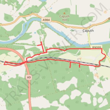
Gravel ride around Murthly Castle
- Distance: 6.2 mi
- Elevation gain: 417 ft
- Maximum elevation: 404 ft
- Elevation loss: 417 ft
- Minimum elevation: 180 ft
- Moving time: 1 h 9 m
- Moving speed: 5.4 mph
- Maximum speed: 16.5 mph
- Total time: 1 h 52 m
- Global speed: 3.3 mph
Interactive trail map
Trail profile
- Distance: 6.2 mi
- Elevation gain: 417 ft
- Maximum elevation: 404 ft
- Elevation loss: 417 ft
- Minimum elevation: 180 ft
- Moving time: 1 h 9 m
- Moving speed: 5.4 mph
- Maximum speed: 16.5 mph
- Total time: 1 h 52 m
- Global speed: 3.3 mph
About this trail
Name: Gravel ride around Murthly Castle trail, distance, elevation, map, profile, GPS track
Start: B9099, Gellyburn, Murthly, Perth and Kinross, Scotland, PH1 4HN, United Kingdom (56.53687 -3.47600)
End: B9099, Gellyburn, Murthly, Perth and Kinross, Scotland, PH1 4HN, United Kingdom (56.53691 -3.47600)
Coordinates: 56.53134 -3.53190 56.53964 -3.47371
Other hiking, mountain biking, running and outdoor activity trails
Click on a trail to view its statistics, map and profile.
Mountain Bike loop ride around Murthly, Perthshire Scotland
United Kingdom > Scotland > Perth and Kinross > Murthly > Gellyburn
UK, Perthshire, Dunkeld, Murthly
Distance: 11.2 mi • Elevation gain: 978 ft • Maximum elevation: 584 ft
EMTB Gravel: Murthly - Birnam - Loop
United Kingdom > Scotland > Perth and Kinross > Newlands
Around Dunkeld, Perthshire Scotland
Distance: 28.8 mi • Elevation gain: 2,851 ft • Maximum elevation: 1,001 ft
Kinclaven Wood - Stanley - Bankfoot Loop
United Kingdom > Scotland > Perth and Kinross > Newlands
Distance: 26.7 mi • Elevation gain: 1,795 ft • Maximum elevation: 449 ft
King's Myre Loop
United Kingdom > Scotland > Perth and Kinross > Newlands
Distance: 24.7 mi • Elevation gain: 1,198 ft • Maximum elevation: 348 ft