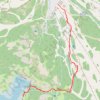
Lake Catherine Loop
Starting at Brighton Resort in Big Cottonwood Canyon, the loop leaves the ski-area base and climbs into the Brighton Lakes corridor, crossing open slopes, conifer patches, and a stream-fed drainage on the way toward Lake Mary.
Beyond the dam and shoreline of Lake Mary, the route continues into a higher alpine setting, passing Lake Martha and open meadows before reaching Lake Catherine, with Mount Millicent, Mount Wolverine, Mount Tuscarora, Pioneer Peak, and Sunset Peak shaping the surrounding skyline.
The itinerary bends around the clear basin of Lake Catherine, then returns north through the same chain of lakes, with recurring views toward Dog Lake, the Brighton ski slopes, and the forested folds of Uinta-Wasatch-Cache National Forest.
#Hiking #Mountain #Forest #Lake #Loop #Nature #Alpine #Wilderness
- Distance: 4.7 mi
- Elevation gain: 1,224 ft
- Maximum elevation: 9,957 ft
- Elevation loss: 1,224 ft
- Minimum elevation: 8,780 ft
- Moving time: 2 h 49 m
- Moving speed: 1.6 mph
- Maximum speed: 3.6 mph
- Total time: 3 h 23 m
- Global speed: 1.4 mph
Interactive trail map
Trail profile
- Distance: 4.7 mi
- Elevation gain: 1,224 ft
- Maximum elevation: 9,957 ft
- Elevation loss: 1,224 ft
- Minimum elevation: 8,780 ft
- Moving time: 2 h 49 m
- Moving speed: 1.6 mph
- Maximum speed: 3.6 mph
- Total time: 3 h 23 m
- Global speed: 1.4 mph
About this trail
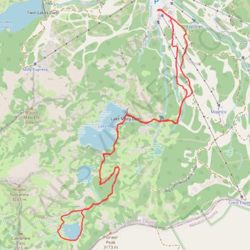
Name: Lake Catherine Loop trail, distance, elevation, map, profile, GPS track
Coordinates: 40.58017 -111.59479 40.59826 -111.58092
Topography: Salt Lake County topographic map, elevation, terrain
Other hiking, mountain biking, running and outdoor activity trails
Click on a trail to view its statistics, map and profile.
Lake Mary via Brighton Lakes Trail in Uinta-Wasatch-Cache National Forest
United States > Utah > Salt Lake County > Brighton
The Lake Mary Trail in Utah's Uinta-Wasatch-Cache National Forest offers a moderately challenging hike through dense forests of aspens and pines, leading to the serene alpine Lake Mary nestled beneath rugged cliffs. Along the way, hikers can enjoy panoramic views of surrounding peaks, including the impressive…
Distance: 2.3 mi • Elevation gain: 758 ft • Maximum elevation: 9,544 ft
Lake Catherine via Brighton Lakes Trail and Catherine's Pass Trail
United States > Utah > Salt Lake County > Brighton
This hike to Lake Catherine offers an immersive experience in the alpine beauty of the Uinta-Wasatch-Cache National Forest. The route leads you past three picturesque lakes—Lake Mary, Lake Martha, and Lake Catherine—while providing panoramic views of the surrounding peaks, like Mt. Wolverine, and lush…
Distance: 2.2 mi • Elevation gain: 1,224 ft • Maximum elevation: 10,000 ft
Lake Mary Dam via Catherine's Pass Trail
United States > Utah > Salt Lake County > Alta
The Lake Mary Dam hike via Catherine’s Pass Trail offers a scenic and rewarding journey through the Uinta-Wasatch-Cache National Forest. Along the way, you'll encounter picturesque alpine lakes such as Lake Mary, Lake Martha, and Lake Catherine, with stunning views of rugged peaks like Mount Millicent. The…
Distance: 6.2 mi • Elevation gain: 1,765 ft • Maximum elevation: 10,223 ft
Lake Catherine Loop via Brighton Lakes Trail in Uinta-Wasatch-Cache National Forest
United States > Utah > Salt Lake County > Brighton
The Lake Catherine Loop via Brighton Lakes Trail offers hikers a journey through alpine forests, passing serene bodies of water like Lake Mary, Lake Martha, and Lake Catherine. Along the trail, one can admire the rugged silhouette of Mount Millicent and, during the summer months, vibrant wildflowers that dot…
Distance: 4.7 mi • Elevation gain: 1,342 ft • Maximum elevation: 10,033 ft