Make a donation
Gear up for your next adventure:
As an Amazon Associate, this site earns from qualifying purchases at no extra cost to you.
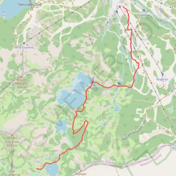
Lake Catherine via Brighton Lakes Trail and Catherine's Pass Trail
This hike to Lake Catherine offers an immersive experience in the alpine beauty of the Uinta-Wasatch-Cache National Forest. The route leads you past three picturesque lakes—Lake Mary, Lake Martha, and Lake Catherine—while providing panoramic views of the surrounding peaks, like Mt. Wolverine, and lush valleys. Along the way, you may encounter local wildlife like moose and birds, and during summer months, the trail is adorned with vibrant wildflowers, making it an ideal hike for nature lovers and photographers. #Hiking #Mountain #Forest #Nature #Lake
- Distance: 2.2 mi
- Elevation gain: 1,224 ft
- Maximum elevation: 10,000 ft
- Elevation loss: 39 ft
- Minimum elevation: 8,812 ft
Interactive trail map
Make a donation
Gear up for your next adventure:
As an Amazon Associate, this site earns from qualifying purchases at no extra cost to you.
Trail profile
- Distance: 2.2 mi
- Elevation gain: 1,224 ft
- Maximum elevation: 10,000 ft
- Elevation loss: 39 ft
- Minimum elevation: 8,812 ft
Make a donation
Gear up for your next adventure:
As an Amazon Associate, this site earns from qualifying purchases at no extra cost to you.
About this trail
Name: Lake Catherine via Brighton Lakes Trail and Catherine's Pass Trail trail, distance, elevation, map, profile, GPS track
End: Catherines Pass Trail, Brighton, Salt Lake County, Utah, United States (40.58106 -111.59534)
Coordinates: 40.58092 -111.59535 40.59779 -111.58146
Topography: Salt Lake County topographic map, elevation, terrain
Make a donation
Gear up for your next adventure:
As an Amazon Associate, this site earns from qualifying purchases at no extra cost to you.
Other hiking, mountain biking, running and outdoor activity trails
Click on a trail to view its statistics, map and profile.
Lake Mary Dam via Catherine's Pass Trail
United States > Utah > Salt Lake County > Alta
The Lake Mary Dam hike via Catherine’s Pass Trail offers a scenic and rewarding journey through the Uinta-Wasatch-Cache National Forest. Along the way, you'll encounter picturesque alpine lakes such as Lake Mary, Lake Martha, and Lake Catherine, with stunning views of rugged peaks like Mount Millicent. The…
Distance: 6.2 mi • Elevation gain: 1,765 ft • Maximum elevation: 10,223 ft
Lake Mary via Brighton Lakes Trail in Uinta-Wasatch-Cache National Forest
United States > Utah > Salt Lake County > Brighton
The Lake Mary Trail in Utah's Uinta-Wasatch-Cache National Forest offers a moderately challenging hike through dense forests of aspens and pines, leading to the serene alpine Lake Mary nestled beneath rugged cliffs. Along the way, hikers can enjoy panoramic views of surrounding peaks, including the impressive…
Distance: 2.3 mi • Elevation gain: 758 ft • Maximum elevation: 9,544 ft
Lake Catherine Loop via Brighton Lakes Trail in Uinta-Wasatch-Cache National Forest
United States > Utah > Salt Lake County > Brighton
The Lake Catherine Loop via Brighton Lakes Trail offers hikers a journey through alpine forests, passing serene bodies of water like Lake Mary, Lake Martha, and Lake Catherine. Along the trail, one can admire the rugged silhouette of Mount Millicent and, during the summer months, vibrant wildflowers that dot…
Distance: 4.7 mi • Elevation gain: 1,342 ft • Maximum elevation: 10,033 ft
Make a donation
Gear up for your next adventure:
As an Amazon Associate, this site earns from qualifying purchases at no extra cost to you.