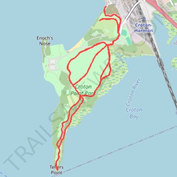
Trace of trails at Croton Point Park
- Distance: 8.0 mi
- Elevation gain: 535 ft
- Maximum elevation: 115 ft
- Elevation loss: 528 ft
- Minimum elevation: 7 ft
- Moving time: 2 h 47 m
- Moving speed: 2.9 mph
- Maximum speed: 4.3 mph
- Total time: 2 h 51 m
- Global speed: 2.8 mph
Interactive trail map
Trail profile
- Distance: 8.0 mi
- Elevation gain: 535 ft
- Maximum elevation: 115 ft
- Elevation loss: 528 ft
- Minimum elevation: 7 ft
- Moving time: 2 h 47 m
- Moving speed: 2.9 mph
- Maximum speed: 4.3 mph
- Total time: 2 h 51 m
- Global speed: 2.8 mph
About this trail
Name: Trace of trails at Croton Point Park trail, distance, elevation, map, profile, GPS track
Coordinates: 41.16876 -73.89887 41.19156 -73.88686
Topography: Westchester County topographic map, elevation, terrain
Other hiking, mountain biking, running and outdoor activity trails
Click on a trail to view its statistics, map and profile.
Old Croton Aqueduct Trail and Bronx
United States > New York > Westchester County > Village of Croton-on-Hudson
Distance: 44.0 mi • Elevation gain: 2,700 ft • Maximum elevation: 262 ft