Make a donation
Gear up for your next adventure:
As an Amazon Associate, this site earns from qualifying purchases at no extra cost to you.
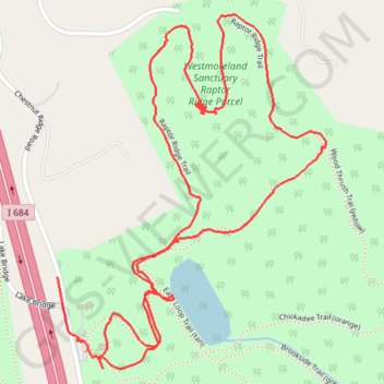
Westmoreland Sanctuary Raptor Ridge New Trail
Sanctuary Summit Hike
- Distance: 2.2 mi
- Elevation gain: 269 ft
- Maximum elevation: 804 ft
- Elevation loss: 289 ft
- Minimum elevation: 581 ft
- Moving time: 1 h 3 m
- Moving speed: 2.1 mph
- Maximum speed: 23.7 mph
- Total time: 1 h 20 m
- Global speed: 1.7 mph
Interactive trail map
Make a donation
Gear up for your next adventure:
As an Amazon Associate, this site earns from qualifying purchases at no extra cost to you.
Trail profile
- Distance: 2.2 mi
- Elevation gain: 269 ft
- Maximum elevation: 804 ft
- Elevation loss: 289 ft
- Minimum elevation: 581 ft
- Moving time: 1 h 3 m
- Moving speed: 2.1 mph
- Maximum speed: 23.7 mph
- Total time: 1 h 20 m
- Global speed: 1.7 mph
Make a donation
Gear up for your next adventure:
As an Amazon Associate, this site earns from qualifying purchases at no extra cost to you.
About this trail
Name: Westmoreland Sanctuary Raptor Ridge New Trail trail, distance, elevation, map, profile, GPS track
Coordinates: 41.17985 -73.68504 41.18679 -73.67805
Topography: Westchester County topographic map, elevation, terrain
Make a donation
Gear up for your next adventure:
As an Amazon Associate, this site earns from qualifying purchases at no extra cost to you.
Other hiking, mountain biking, running and outdoor activity trails
Click on a trail to view its statistics, map and profile.
Afternoon hike at Westmoreland Grand Tour
United States > New York > Westchester County > Town of Bedford
Distance: 4.2 mi • Elevation gain: 620 ft • Maximum elevation: 741 ft
Westmoreland Sanctuary Grand Tour
United States > New York > Westchester County > Town of Bedford
Distance: 4.0 mi • Elevation gain: 577 ft • Maximum elevation: 741 ft
Westmoreland Sanctuary Loop
United States > New York > Westchester County > Town of Bedford
Distance: 5.5 mi • Elevation gain: 764 ft • Maximum elevation: 741 ft
Make a donation
Gear up for your next adventure:
As an Amazon Associate, this site earns from qualifying purchases at no extra cost to you.