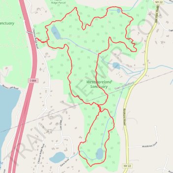
Westmoreland Sanctuary Loop
- Distance: 5.5 mi
- Elevation gain: 764 ft
- Maximum elevation: 741 ft
- Elevation loss: 764 ft
- Minimum elevation: 436 ft
- Moving time: 2 h 17 m
- Moving speed: 2.4 mph
- Maximum speed: 4.8 mph
- Total time: 2 h 20 m
- Global speed: 2.4 mph
Interactive trail map
Trail profile
- Distance: 5.5 mi
- Elevation gain: 764 ft
- Maximum elevation: 741 ft
- Elevation loss: 764 ft
- Minimum elevation: 436 ft
- Moving time: 2 h 17 m
- Moving speed: 2.4 mph
- Maximum speed: 4.8 mph
- Total time: 2 h 20 m
- Global speed: 2.4 mph
About this trail
Name: Westmoreland Sanctuary Loop trail, distance, elevation, map, profile, GPS track
Coordinates: 41.16468 -73.68451 41.18437 -73.66814
Topography: Westchester County topographic map, elevation, terrain
Other hiking, mountain biking, running and outdoor activity trails
Click on a trail to view its statistics, map and profile.
Westmoreland Sanctuary Raptor Ridge New Trail
United States > New York > Westchester County > Town of Bedford
Sanctuary Summit Hike
Distance: 2.2 mi • Elevation gain: 269 ft • Maximum elevation: 804 ft
Afternoon hike at Westmoreland Grand Tour
United States > New York > Westchester County > Town of Bedford
Distance: 4.2 mi • Elevation gain: 620 ft • Maximum elevation: 741 ft
Westmoreland Sanctuary Grand Tour
United States > New York > Westchester County > Town of Bedford
Distance: 4.0 mi • Elevation gain: 577 ft • Maximum elevation: 741 ft