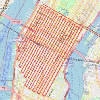
Import a GPX file

New

  • Distance: 55.0 mi
  • Elevation gain: 4,708 ft
  • Maximum elevation: 207 ft
  • Elevation loss: 4,701 ft
  • Minimum elevation: 7 ft

Interactive trail map

Trail profile

  • Distance: 55.0 mi
  • Elevation gain: 4,708 ft
  • Maximum elevation: 207 ft
  • Elevation loss: 4,701 ft
  • Minimum elevation: 7 ft

About this trail

Other hiking, mountain biking, running and outdoor activity trails

Click on a trail to view its statistics, map and profile.

New York City Marathon

United States > New York > New York

Marathon from Staten Island to Central Park. #Marathon #Running #City #Sea #River #Park #Atlantic #Ocean

Distance: 26.9 mi • Elevation gain: 1,276 ft • Maximum elevation: 148 ft

Walk in Manhattan

United States > New York > New York County > New York

Hike through famous places of Manhattan from Central Park to Battery Park. #Walking #Hiking #Manhattan #NewYork #City #Park #Sea

Distance: 16.0 mi • Elevation gain: 1,686 ft • Maximum elevation: 207 ft

Montréal - New York

Canada > Quebec > Urban agglomeration of Montreal > Montreal

#Bike #Montréal #NewYork

Distance: 396.2 mi • Elevation gain: 15,945 ft • Maximum elevation: 988 ft

Gear up for your next adventure:

🚗GPS Dash Cams - Record your scenic drives through mountain passes and canyons
🩹Survival Bandages - High‑quality bandages for emergencies
🦟Ultrasonic Repellers - Create a bug-free zone at your camp or rest stop
🔭Stargazing Telescopes - Perfect for camping in low-light pollution areas shown on maps
🚁Photography Drones - Capture stunning aerial views of landforms and topography

As an Amazon Associate, this site earns from qualifying purchases at no extra cost to you.