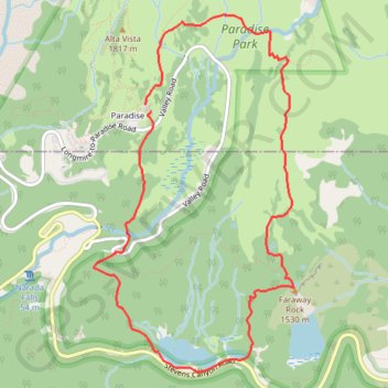
Faraway Rock Loop via Mazama Ridge Trail in Mount Rainier National Park
The Faraway Rock Loop via Mazama Ridge Trail offers a peaceful yet rewarding hike through Mount Rainier National Park, where hikers are treated to expansive views of the surrounding wilderness. The route meanders through vibrant wildflower meadows in the summer, with stunning sights of Mount Rainier, the Tatoosh Range, the Reflection Lakes and the Louise Lake basin below, making it a photographer's dream. Notable for its easy accessibility and moderate challenge, the hike leads to Faraway Rock, a scenic viewpoint that provides a tranquil spot to relax and soak in the beauty of the landscape. #Hiking #Mountain #Forest #Nature #Loop #Lake #Overlook
- Distance: 5.2 mi
- Elevation gain: 1,352 ft
- Maximum elevation: 5,784 ft
- Elevation loss: 1,378 ft
- Minimum elevation: 4,839 ft
Interactive trail map
Trail profile
- Distance: 5.2 mi
- Elevation gain: 1,352 ft
- Maximum elevation: 5,784 ft
- Elevation loss: 1,378 ft
- Minimum elevation: 4,839 ft
About this trail
Name: Faraway Rock Loop via Mazama Ridge Trail in Mount Rainier National Park trail, distance, elevation, map, profile, GPS track
Start: Guide House Trail, Paradise, Pierce County, Washington, United States (46.78708 -121.73421)
Coordinates: 46.76812 -121.73948 46.79343 -121.71896
Topography: Pierce County topographic map, elevation, terrain
Other hiking, mountain biking, running and outdoor activity trails
Click on a trail to view its statistics, map and profile.
Camp Muir via Syline Trail and Camp Muir Route in Mount Rainier National Park
United States > Washington > Pierce County > Paradise
The hike to Camp Muir via the Skyline Trail and Muir Snowfield in Mount Rainier National Park offers a breathtaking journey through vibrant wildflower meadows, rocky terrain, and expansive snowfields. As you ascend, views of nearby volcanic peaks, hanging glaciers, and ridges like Tatoosh open up, making each…
Distance: 8.4 mi • Elevation gain: 4,678 ft • Maximum elevation: 10,046 ft
Panorama Point Loop via Skyline Trail in Mount Rainier National Park
United States > Washington > Pierce County > Paradise
The Panorama Point Loop via Skyline Trail offers an unforgettable hiking experience in Mount Rainier National Park. Hikers are treated to spectacular panoramic views, including close-up vistas of the towering Mount Rainier, the Nisqually Glacier, and sweeping landscapes dotted with wildflowers in the summer.…
Distance: 5.6 mi • Elevation gain: 1,864 ft • Maximum elevation: 7,031 ft
Panorama Point, Golden Gate Falls and Myrtle Falls Loop
United States > Washington > Pierce County > Paradise
Loop hike from Paradise to Panorama Point via Relief Map of Mount Rainier, Skyline Trail, Dead Horse Creek Trail, Glacier Vista Trail, Glacier Vista, Upper Skyline Trail, Golden Gate Trail, Golden Gate Falls and Myrtle Falls Viewpoint in the Mount Rainier National Park and the Paradise Park. #Hiking #Loop…
Distance: 4.7 mi • Elevation gain: 1,759 ft • Maximum elevation: 7,044 ft
Skyline Loop Trail via Panorama Point in Mount Rainier National Park
United States > Washington > Pierce County > Paradise
The Skyline Loop Trail via Panorama Point in Mount Rainier National Park offers an unforgettable hiking experience characterized by breathtaking views and diverse landscapes. As you traverse the trail, you'll encounter vibrant wildflower meadows, glacial vistas, and panoramic views of iconic peaks, including…
Distance: 5.9 mi • Elevation gain: 1,906 ft • Maximum elevation: 7,031 ft
Glacier Vista via Skyline Trail in Mount Rainier National Park
United States > Washington > Pierce County > Paradise
The Glacier Vista via Skyline Trail offers breathtaking views of Mount Rainier and the Nisqually Glacier, with expansive vistas of the surrounding valleys. As hikers ascend, they will pass through wildflower meadows in the warmer months and experience dramatic alpine terrain, often encountering glaciers and…
Distance: 1.3 mi • Elevation gain: 978 ft • Maximum elevation: 6,401 ft
Northern part of the Pacific Crest Trail (PCT)
United States > Oregon > Klamath County
Hike on the Pacific Crest National Scenic Trail from Crater Lake to Canada Border through Oregon and Washington along the Sierra Nevada and Cascade mountain ranges. #Hiking #Mountain #SierraNevada #Cascade #Nature #Forest #Park #PCT
Distance: 744.6 mi • Elevation gain: 145,367 ft • Maximum elevation: 7,569 ft
Myrtle Falls Viewpoint via Skyline Trail
United States > Washington > Pierce County > Paradise
Distance: 1.3 mi • Elevation gain: 240 ft • Maximum elevation: 5,587 ft
Hike to Plummer Peak and Denman Peak via Pinnacle Peak Trail and Pinnacle Saddle in the Mount Rainier National Park
United States > Washington > Lewis County
Distance: 5.1 mi • Elevation gain: 1,864 ft • Maximum elevation: 6,207 ft
Plummer Peak via Pinnacle Peak Trail
United States > Washington > Lewis County
Distance: 5.2 mi • Elevation gain: 1,893 ft • Maximum elevation: 6,214 ft
New Track 9/24/22 6:13:29 AM
United States > Washington > Lewis County
Distance: 4.7 mi • Elevation gain: 2,474 ft • Maximum elevation: 6,424 ft
Narada Falls
United States > Washington > Lewis County
Distance: 3.5 mi • Elevation gain: 1,060 ft • Maximum elevation: 5,427 ft