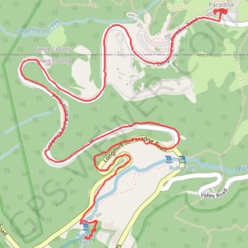
Narada Falls
- Distance: 3.5 mi
- Elevation gain: 1,060 ft
- Maximum elevation: 5,427 ft
- Elevation loss: 217 ft
- Minimum elevation: 4,511 ft
Interactive trail map
Trail profile
- Distance: 3.5 mi
- Elevation gain: 1,060 ft
- Maximum elevation: 5,427 ft
- Elevation loss: 217 ft
- Minimum elevation: 4,511 ft
About this trail
Name: Narada Falls trail, distance, elevation, map, profile, GPS track
Start: Narada Falls Trail, Lewis County, Washington, United States (46.77525 -121.74558)
Coordinates: 46.77439 -121.75099 46.78608 -121.73558
Topography: Lewis County topographic map, elevation, terrain
Other hiking, mountain biking, running and outdoor activity trails
Click on a trail to view its statistics, map and profile.
Panorama Point Loop via Skyline Trail in Mount Rainier National Park
United States > Washington > Pierce County > Paradise
The Panorama Point Loop via Skyline Trail offers an unforgettable hiking experience in Mount Rainier National Park. Hikers are treated to spectacular panoramic views, including close-up vistas of the towering Mount Rainier, the Nisqually Glacier, and sweeping landscapes dotted with wildflowers in the summer.…
Distance: 5.6 mi • Elevation gain: 1,864 ft • Maximum elevation: 7,031 ft
Faraway Rock Loop via Mazama Ridge Trail in Mount Rainier National Park
United States > Washington > Pierce County > Paradise
The Faraway Rock Loop via Mazama Ridge Trail offers a peaceful yet rewarding hike through Mount Rainier National Park, where hikers are treated to expansive views of the surrounding wilderness. The route meanders through vibrant wildflower meadows in the summer, with stunning sights of Mount Rainier, the…
Distance: 5.2 mi • Elevation gain: 1,352 ft • Maximum elevation: 5,784 ft
Skyline Loop Trail via Panorama Point in Mount Rainier National Park
United States > Washington > Pierce County > Paradise
The Skyline Loop Trail via Panorama Point in Mount Rainier National Park offers an unforgettable hiking experience characterized by breathtaking views and diverse landscapes. As you traverse the trail, you'll encounter vibrant wildflower meadows, glacial vistas, and panoramic views of iconic peaks, including…
Distance: 5.9 mi • Elevation gain: 1,906 ft • Maximum elevation: 7,031 ft
Panorama Point, Golden Gate Falls and Myrtle Falls Loop
United States > Washington > Pierce County > Paradise
Loop hike from Paradise to Panorama Point via Relief Map of Mount Rainier, Skyline Trail, Dead Horse Creek Trail, Glacier Vista Trail, Glacier Vista, Upper Skyline Trail, Golden Gate Trail, Golden Gate Falls and Myrtle Falls Viewpoint in the Mount Rainier National Park and the Paradise Park. #Hiking #Loop…
Distance: 4.7 mi • Elevation gain: 1,759 ft • Maximum elevation: 7,044 ft
Northern part of the Pacific Crest Trail (PCT)
United States > Oregon > Klamath County
Hike on the Pacific Crest National Scenic Trail from Crater Lake to Canada Border through Oregon and Washington along the Sierra Nevada and Cascade mountain ranges. #Hiking #Mountain #SierraNevada #Cascade #Nature #Forest #Park #PCT
Distance: 744.6 mi • Elevation gain: 145,367 ft • Maximum elevation: 7,569 ft
Myrtle Falls Viewpoint via Skyline Trail
United States > Washington > Pierce County > Paradise
Distance: 1.3 mi • Elevation gain: 240 ft • Maximum elevation: 5,587 ft