Make a donation
Gear up for your next adventure:
As an Amazon Associate, this site earns from qualifying purchases at no extra cost to you.
Rainbow Falls, Turtleback Falls and Drift Falls
Via Rainbow Falls Trail in Nantahala National Forest #Hiking #Waterfall #Forest #River
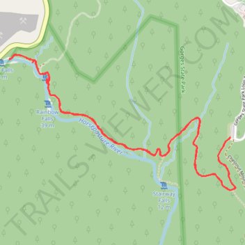
- Distance: 4.0 mi
- Elevation gain: 810 ft
- Maximum elevation: 2,904 ft
- Elevation loss: 807 ft
- Minimum elevation: 2,536 ft
- Moving time: 1 h 50 m
- Moving speed: 2.2 mph
- Maximum speed: 4.0 mph
- Total time: 2 h 3 m
- Global speed: 2.0 mph
Interactive trail map
Make a donation
Gear up for your next adventure:
As an Amazon Associate, this site earns from qualifying purchases at no extra cost to you.
Trail profile
- Distance: 4.0 mi
- Elevation gain: 810 ft
- Maximum elevation: 2,904 ft
- Elevation loss: 807 ft
- Minimum elevation: 2,536 ft
- Moving time: 1 h 50 m
- Moving speed: 2.2 mph
- Maximum speed: 4.0 mph
- Total time: 2 h 3 m
- Global speed: 2.0 mph
Make a donation
Gear up for your next adventure:
As an Amazon Associate, this site earns from qualifying purchases at no extra cost to you.
About this trail
Name: Rainbow Falls, Turtleback Falls and Drift Falls trail, distance, elevation, map, profile, GPS track
Start: Rainbow Falls Trail, Transylvania County, North Carolina, United States (35.08872 -82.95191)
End: Rainbow Falls Trail, Transylvania County, North Carolina, United States (35.08871 -82.95190)
Coordinates: 35.08541 -82.96892 35.09396 -82.95150
Topography: Transylvania County topographic map, elevation, terrain
Make a donation
Gear up for your next adventure:
As an Amazon Associate, this site earns from qualifying purchases at no extra cost to you.
Other hiking, mountain biking, running and outdoor activity trails
Click on a trail to view its statistics, map and profile.
Rainbow Falls, Turtleback Falls and Drift Falls via Rainbow Falls Trail
United States > North Carolina > Transylvania County
The Rainbow Falls Trail in North Carolina's Nantahala National Forest offers hikers a scenic journey along the Horsepasture River, leading to three remarkable waterfalls. The trail first reveals the impressive Rainbow Falls, where water cascades down a towering cliff, often creating vibrant rainbows in its…
Distance: 4.0 mi • Elevation gain: 801 ft • Maximum elevation: 2,910 ft