Make a donation
Gear up for your next adventure:
As an Amazon Associate, this site earns from qualifying purchases at no extra cost to you.
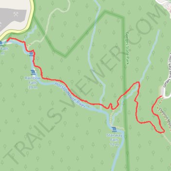
Rainbow Falls, Turtleback Falls and Drift Falls via Rainbow Falls Trail
The Rainbow Falls Trail in North Carolina's Nantahala National Forest offers hikers a scenic journey along the Horsepasture River, leading to three remarkable waterfalls. The trail first reveals the impressive Rainbow Falls, where water cascades down a towering cliff, often creating vibrant rainbows in its mist. Continuing upstream, hikers encounter Turtleback Falls, known for its unique curved rock formation, and finally Drift Falls, a picturesque slide waterfall visible from the trail's end. #Hiking #Waterfall #Forest #River #Nature
- Distance: 4.0 mi
- Elevation gain: 801 ft
- Maximum elevation: 2,910 ft
- Elevation loss: 801 ft
- Minimum elevation: 2,536 ft
- Moving time: 1 h 48 m
- Moving speed: 2.2 mph
- Maximum speed: 3.9 mph
- Total time: 2 h 1 m
- Global speed: 2.0 mph
Interactive trail map
Make a donation
Gear up for your next adventure:
As an Amazon Associate, this site earns from qualifying purchases at no extra cost to you.
Trail profile
- Distance: 4.0 mi
- Elevation gain: 801 ft
- Maximum elevation: 2,910 ft
- Elevation loss: 801 ft
- Minimum elevation: 2,536 ft
- Moving time: 1 h 48 m
- Moving speed: 2.2 mph
- Maximum speed: 3.9 mph
- Total time: 2 h 1 m
- Global speed: 2.0 mph
Make a donation
Gear up for your next adventure:
As an Amazon Associate, this site earns from qualifying purchases at no extra cost to you.
About this trail
Name: Rainbow Falls, Turtleback Falls and Drift Falls via Rainbow Falls Trail trail, distance, elevation, map, profile, GPS track
Start: Rainbow Falls Trail, Transylvania County, North Carolina, United States (35.08872 -82.95182)
End: Rainbow Falls Trail, Transylvania County, North Carolina, United States (35.08874 -82.95180)
Coordinates: 35.08542 -82.96889 35.09395 -82.95151
Topography: Transylvania County topographic map, elevation, terrain
Make a donation
Gear up for your next adventure:
As an Amazon Associate, this site earns from qualifying purchases at no extra cost to you.
Other hiking, mountain biking, running and outdoor activity trails
Click on a trail to view its statistics, map and profile.