Westerdale top
Mountain Biking
- Distance: 17.0 mi
- Elevation gain: 2,175 ft
- Maximum elevation: 1,385 ft
- Elevation loss: 2,175 ft
- Minimum elevation: 597 ft
- Moving time: 2 h 56 m
- Moving speed: 5.8 mph
- Maximum speed: 27.9 mph
- Total time: 3 h 17 m
- Global speed: 5.2 mph
Interactive trail map
Trail profile
- Distance: 17.0 mi
- Elevation gain: 2,175 ft
- Maximum elevation: 1,385 ft
- Elevation loss: 2,175 ft
- Minimum elevation: 597 ft
- Moving time: 2 h 56 m
- Moving speed: 5.8 mph
- Maximum speed: 27.9 mph
- Total time: 3 h 17 m
- Global speed: 5.2 mph
About this trail
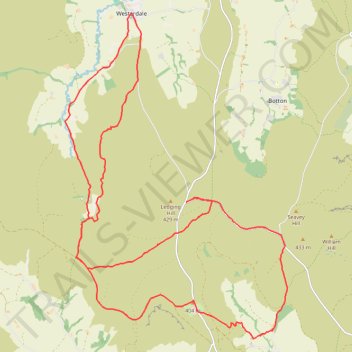
Name: Westerdale top trail, distance, elevation, map, profile, GPS track
Coordinates: 54.38247 -0.99785 54.44394 -0.92562
Other hiking, mountain biking, running and outdoor activity trails
Click on a trail to view its statistics, map and profile.
Rosedale Abbey north loop to Fryup Dale
United Kingdom > England > North Yorkshire > Rosedale Abbey
Distance: 19.8 mi • Elevation gain: 2,300 ft • Maximum elevation: 1,385 ft
Church Houses Loop Mountain Biking
United Kingdom > England > North Yorkshire > Church Houses
Distance: 14.3 mi • Elevation gain: 2,116 ft • Maximum elevation: 1,289 ft
Westerdale Kildale Loop
United Kingdom > England > North Yorkshire > Westerdale
Scarborough Mountain Biking
Distance: 12.1 mi • Elevation gain: 1,988 ft • Maximum elevation: 1,119 ft
Farndale
United Kingdom > England > North Yorkshire > Appleton-le-Moors
Ryedale Mountain Biking
Distance: 32.9 mi • Elevation gain: 4,104 ft • Maximum elevation: 1,335 ft