Make a donation
Gear up for your next adventure:
As an Amazon Associate, this site earns from qualifying purchases at no extra cost to you.
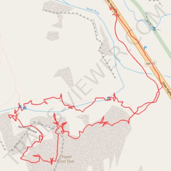
Bob's Knob climbing route on the Chapel Pond Slab and descent. New York, USA
- Distance: 1.0 mi
- Elevation gain: 535 ft
- Maximum elevation: 2,149 ft
- Elevation loss: 538 ft
- Minimum elevation: 1,644 ft
- Moving time: 32 m 27 s
- Moving speed: 1.9 mph
- Maximum speed: 5.5 mph
- Total time: 6 h 42 s
- Global speed: 0.2 mph
Interactive trail map
Make a donation
Gear up for your next adventure:
As an Amazon Associate, this site earns from qualifying purchases at no extra cost to you.
Trail profile
- Distance: 1.0 mi
- Elevation gain: 535 ft
- Maximum elevation: 2,149 ft
- Elevation loss: 538 ft
- Minimum elevation: 1,644 ft
- Moving time: 32 m 27 s
- Moving speed: 1.9 mph
- Maximum speed: 5.5 mph
- Total time: 6 h 42 s
- Global speed: 0.2 mph
Make a donation
Gear up for your next adventure:
As an Amazon Associate, this site earns from qualifying purchases at no extra cost to you.
About this trail
Name: Bob's Knob climbing route on the Chapel Pond Slab and descent. New York, USA trail, distance, elevation, map, profile, GPS track
Start: State Highway 73, Town of Keene, Essex County, New York, United States (44.13761 -73.74320)
End: State Highway 73, Town of Keene, Essex County, New York, United States (44.13773 -73.74326)
Coordinates: 44.13541 -73.74532 44.13773 -73.74218
Topography: Essex County topographic map, elevation, terrain
Make a donation
Gear up for your next adventure:
As an Amazon Associate, this site earns from qualifying purchases at no extra cost to you.
Other hiking, mountain biking, running and outdoor activity trails
Click on a trail to view its statistics, map and profile.
Chapel Pond Slab rock climbing and descent (New York, USA)
United States > New York > Essex County > Town of Keene
Distance: 0.7 mi • Elevation gain: 472 ft • Maximum elevation: 2,146 ft