Make a donation
Gear up for your next adventure:
As an Amazon Associate, this site earns from qualifying purchases at no extra cost to you.
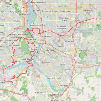
Lake Oswego trails
Happy Hour Lake Oswego
- Distance: 43.2 mi
- Elevation gain: 3,848 ft
- Maximum elevation: 728 ft
- Elevation loss: 3,858 ft
- Minimum elevation: 10 ft
- Moving time: 3 h 22 m
- Moving speed: 12.8 mph
- Maximum speed: 34.1 mph
- Total time: 4 h 6 m
- Global speed: 10.5 mph
Interactive trail map
Make a donation
Gear up for your next adventure:
As an Amazon Associate, this site earns from qualifying purchases at no extra cost to you.
Trail profile
- Distance: 43.2 mi
- Elevation gain: 3,848 ft
- Maximum elevation: 728 ft
- Elevation loss: 3,858 ft
- Minimum elevation: 10 ft
- Moving time: 3 h 22 m
- Moving speed: 12.8 mph
- Maximum speed: 34.1 mph
- Total time: 4 h 6 m
- Global speed: 10.5 mph
Make a donation
Gear up for your next adventure:
As an Amazon Associate, this site earns from qualifying purchases at no extra cost to you.
About this trail
Name: Lake Oswego trails trail, distance, elevation, map, profile, GPS track
Coordinates: 45.38413 -122.72311 45.48237 -122.51994
Topography: Portland topographic map, elevation, terrain
Make a donation
Gear up for your next adventure:
As an Amazon Associate, this site earns from qualifying purchases at no extra cost to you.
Other hiking, mountain biking, running and outdoor activity trails
Click on a trail to view its statistics, map and profile.
Portland Cyclocross - Happy Valley trails
United States > Oregon > Multnomah County > Portland
Distance: 13.1 mi • Elevation gain: 1,801 ft • Maximum elevation: 1,053 ft
Portland Gravel/Unpaved Cycling
United States > Oregon > Multnomah County > Portland
Distance: 31.0 mi • Elevation gain: 1,837 ft • Maximum elevation: 476 ft
Expedition to Sedum Ridge
United States > Oregon > Multnomah County > Portland
Distance: 133.4 mi • Elevation gain: 16,709 ft • Maximum elevation: 3,835 ft
The Watcher in the Water
United States > Oregon > Multnomah County > Portland
Distance: 51.5 mi • Elevation gain: 4,760 ft • Maximum elevation: 984 ft
Make a donation
Gear up for your next adventure:
As an Amazon Associate, this site earns from qualifying purchases at no extra cost to you.
3-Creeks Natural Area loop
United States > Oregon > Clackamas County > Milwaukie
Distance: 1.7 mi • Elevation gain: 98 ft • Maximum elevation: 141 ft