The Watcher in the Water
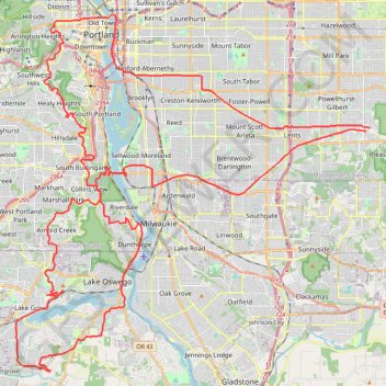
- Distance: 51.5 mi
- Elevation gain: 4,760 ft
- Maximum elevation: 984 ft
- Elevation loss: 4,780 ft
- Minimum elevation: 10 ft
Interactive trail map
Trail profile
- Distance: 51.5 mi
- Elevation gain: 4,760 ft
- Maximum elevation: 984 ft
- Elevation loss: 4,780 ft
- Minimum elevation: 10 ft
About this trail
Name: The Watcher in the Water trail, distance, elevation, map, profile, GPS track
Coordinates: 45.38413 -122.72313 45.52806 -122.51993
Topography: Portland topographic map, elevation, terrain
Other hiking, mountain biking, running and outdoor activity trails
Click on a trail to view its statistics, map and profile.
Lower Macleay Trail and Wildwood Trail to Pittock Mansion
United States > Oregon > Multnomah County > Portland
The hike to Pittock Mansion via the Lower Macleay and Wildwood Trails is an enjoyable route through Portland’s lush Forest Park, offering a variety of natural sights. Starting from Lower Macleay Park, you will pass the Witch's Castle, a unique stone structure hidden in the woods, cross over Balch Creek, and…
Distance: 5.3 mi • Elevation gain: 1,329 ft • Maximum elevation: 968 ft
Great Northwest Loop in Washington Park
United States > Oregon > Multnomah County > Portland
The Great Northwest Loop offers a pleasant and scenic escape with a variety of highlights. As you hike, you'll pass through lush forests filled with tall trees, including Douglas-firs and maples, along well-maintained paths that lead to stunning vistas. The route also connects several renowned park…
Distance: 4.5 mi • Elevation gain: 784 ft • Maximum elevation: 879 ft
Loop hike via Pittock Acres Park, Wilwood Trail, Hoyt Arboretum, Magnolia Trail, Washington Park and Japanes Garden Trail
United States > Oregon > Multnomah County > Portland
Distance: 4.1 mi • Elevation gain: 617 ft • Maximum elevation: 820 ft
Portland Cyclocross - Happy Valley trails
United States > Oregon > Multnomah County > Portland
Distance: 13.1 mi • Elevation gain: 1,801 ft • Maximum elevation: 1,053 ft
Portland Gravel/Unpaved Cycling
United States > Oregon > Multnomah County > Portland
Distance: 31.0 mi • Elevation gain: 1,837 ft • Maximum elevation: 476 ft
Expedition to Sedum Ridge
United States > Oregon > Multnomah County > Portland
Distance: 133.4 mi • Elevation gain: 16,709 ft • Maximum elevation: 3,835 ft
Lake Oswego trails
United States > Oregon > Multnomah County > Portland
Happy Hour Lake Oswego
Distance: 43.2 mi • Elevation gain: 3,848 ft • Maximum elevation: 728 ft
3-Creeks Natural Area loop
United States > Oregon > Clackamas County > Milwaukie
Distance: 1.7 mi • Elevation gain: 98 ft • Maximum elevation: 141 ft