Make a donation
Gear up for your next adventure:
As an Amazon Associate, this site earns from qualifying purchases at no extra cost to you.
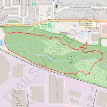
3-Creeks Natural Area loop
- Distance: 1.7 mi
- Elevation gain: 98 ft
- Maximum elevation: 141 ft
- Elevation loss: 98 ft
- Minimum elevation: 75 ft
- Moving time: 1 h 36 s
- Moving speed: 1.7 mph
- Maximum speed: 3.8 mph
- Total time: 1 h 54 m
- Global speed: 0.9 mph
Interactive trail map
Make a donation
Gear up for your next adventure:
As an Amazon Associate, this site earns from qualifying purchases at no extra cost to you.
Trail profile
- Distance: 1.7 mi
- Elevation gain: 98 ft
- Maximum elevation: 141 ft
- Elevation loss: 98 ft
- Minimum elevation: 75 ft
- Moving time: 1 h 36 s
- Moving speed: 1.7 mph
- Maximum speed: 3.8 mph
- Total time: 1 h 54 m
- Global speed: 0.9 mph
Make a donation
Gear up for your next adventure:
As an Amazon Associate, this site earns from qualifying purchases at no extra cost to you.
About this trail
Name: 3-Creeks Natural Area loop trail, distance, elevation, map, profile, GPS track
Coordinates: 45.42806 -122.59292 45.43158 -122.58120
Topography: Clackamas County topographic map, elevation, terrain
Make a donation
Gear up for your next adventure:
As an Amazon Associate, this site earns from qualifying purchases at no extra cost to you.
Other hiking, mountain biking, running and outdoor activity trails
Click on a trail to view its statistics, map and profile.
The Watcher in the Water
United States > Oregon > Multnomah County > Portland
Distance: 51.5 mi • Elevation gain: 4,760 ft • Maximum elevation: 984 ft
Lake Oswego trails
United States > Oregon > Multnomah County > Portland
Happy Hour Lake Oswego
Distance: 43.2 mi • Elevation gain: 3,848 ft • Maximum elevation: 728 ft