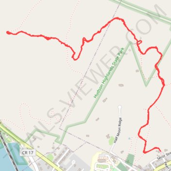
Undercliff Trail from Nelsonville to Breakneck-view point on Bull Hill
- Distance: 4.6 mi
- Elevation gain: 1,050 ft
- Maximum elevation: 1,066 ft
- Elevation loss: 1,050 ft
- Minimum elevation: 220 ft
- Moving time: 2 h 39 m
- Moving speed: 1.7 mph
- Maximum speed: 5.0 mph
- Total time: 6 h 46 m
- Global speed: 0.7 mph
Interactive trail map
Trail profile
- Distance: 4.6 mi
- Elevation gain: 1,050 ft
- Maximum elevation: 1,066 ft
- Elevation loss: 1,050 ft
- Minimum elevation: 220 ft
- Moving time: 2 h 39 m
- Moving speed: 1.7 mph
- Maximum speed: 5.0 mph
- Total time: 6 h 46 m
- Global speed: 0.7 mph
About this trail
Name: Undercliff Trail from Nelsonville to Breakneck-view point on Bull Hill trail, distance, elevation, map, profile, GPS track
Coordinates: 41.42457 -73.96517 41.43495 -73.94900
Topography: Putnam County topographic map, elevation, terrain
Other hiking, mountain biking, running and outdoor activity trails
Click on a trail to view its statistics, map and profile.
Bull Hill Short Loop
United States > New York > Putnam County
Starting near Little Stony Point and Cold Spring, the Bull Hill Short Loop climbs from the Washburn Trailhead through woods toward the old quarry and early Hudson River viewpoints. The route then follows the Undercliff Trail across the shoulder of Bull Hill, passing rock outcrops with views over the Hudson…
Distance: 4.4 mi • Elevation gain: 1,230 ft • Maximum elevation: 1,109 ft
Bull Hill Loop in Hudson Highlands State Park
United States > New York > Putnam County
The Bull Hill Loop offers a scenic and varied hike, with diverse viewpoints over the Hudson River and surrounding highlands. The trail provides steady elevation that can be challenging, but hikers are rewarded with lookouts toward Storm King Mountain, the village of Cold Spring, and even the distant New York…
Distance: 5.4 mi • Elevation gain: 1,398 ft • Maximum elevation: 1,381 ft
Bull Hill Short Loop via Undercliff Trail in Hudson Highlands State Park Preserve
United States > New York > Putnam County
The Bull Hill Short Loop via the Undercliff Trail in Hudson Highlands State Park Preserve offers hikers captivating vistas of the Hudson River, with clear views of Storm King Mountain and Breakneck Ridge. Along the trail, remnants of the historic Cornish Estate provide a glimpse into the area's past. The path…
Distance: 4.4 mi • Elevation gain: 1,227 ft • Maximum elevation: 1,109 ft
From Nelsonville to the Cornish-Undercliff Junction via Nelsonvill Trail, Washburn Trail and Cornish Trail
United States > New York > Putnam County > Village of Nelsonville
Hudson Highlands State Park, Bull Hill, Nelsonville Trail, Washburn Trail, Cornish Trail, Undercliff Trail
Distance: 7.2 mi • Elevation gain: 1,434 ft • Maximum elevation: 1,073 ft
Cornish Trail from trailhead to Undercliff Trail Junction (upper) as well as Undercliff Trail from Cornish Trail Junction (upper) to Breakneck-view point
United States > New York > Putnam County
Hudson Highlands State Park, Cornish Trail, Undercliff Trail, Bull Hill
Distance: 6.3 mi • Elevation gain: 1,306 ft • Maximum elevation: 1,109 ft