Make a donation
Gear up for your next adventure:
As an Amazon Associate, this site earns from qualifying purchases at no extra cost to you.
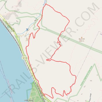
Bull Hill Short Loop via Undercliff Trail in Hudson Highlands State Park Preserve
The Bull Hill Short Loop via the Undercliff Trail in Hudson Highlands State Park Preserve offers hikers captivating vistas of the Hudson River, with clear views of Storm King Mountain and Breakneck Ridge. Along the trail, remnants of the historic Cornish Estate provide a glimpse into the area's past. The path also traverses a reclaimed quarry, showcasing nature's resilience as it reclaims former industrial sites. #Hiking #Loop #Mountain #River #Forest #Overlook #Nature
- Distance: 4.4 mi
- Elevation gain: 1,227 ft
- Maximum elevation: 1,109 ft
- Elevation loss: 1,227 ft
- Minimum elevation: 39 ft
- Moving time: 2 h 40 m
- Moving speed: 1.6 mph
- Maximum speed: 3.4 mph
- Total time: 3 h 36 m
- Global speed: 1.2 mph
Interactive trail map
Make a donation
Gear up for your next adventure:
As an Amazon Associate, this site earns from qualifying purchases at no extra cost to you.
Trail profile
- Distance: 4.4 mi
- Elevation gain: 1,227 ft
- Maximum elevation: 1,109 ft
- Elevation loss: 1,227 ft
- Minimum elevation: 39 ft
- Moving time: 2 h 40 m
- Moving speed: 1.6 mph
- Maximum speed: 3.4 mph
- Total time: 3 h 36 m
- Global speed: 1.2 mph
Make a donation
Gear up for your next adventure:
As an Amazon Associate, this site earns from qualifying purchases at no extra cost to you.
About this trail
Name: Bull Hill Short Loop via Undercliff Trail in Hudson Highlands State Park Preserve trail, distance, elevation, map, profile, GPS track
Coordinates: 41.42636 -73.97037 41.44476 -73.95735
Topography: Putnam County topographic map, elevation, terrain
Make a donation
Gear up for your next adventure:
As an Amazon Associate, this site earns from qualifying purchases at no extra cost to you.
Other hiking, mountain biking, running and outdoor activity trails
Click on a trail to view its statistics, map and profile.
Bull Hill Loop in Hudson Highlands State Park
United States > New York > Putnam County
The Bull Hill Loop offers a scenic and varied hike, with diverse viewpoints over the Hudson River and surrounding highlands. The trail provides steady elevation that can be challenging, but hikers are rewarded with lookouts toward Storm King Mountain, the village of Cold Spring, and even the distant New York…
Distance: 5.4 mi • Elevation gain: 1,398 ft • Maximum elevation: 1,381 ft
Breakneck Ridge Loop via Breakneck Ridge Trail, Breakneck Bypass Trail and Wilkinson Trail in Hudson Highlands State Park Preserve
United States > New York > Dutchess County > Town of Fishkill > Dutchess Junction
The Breakneck Ridge Loop is a thrilling hiking adventure, characterized by its steep ascents and exhilarating rock scrambles. Along the route, hikers are treated to spectacular panoramic views of the Hudson River and surrounding mountains, particularly at the Flagpole area and other scenic points. The trail…
Distance: 3.2 mi • Elevation gain: 1,247 ft • Maximum elevation: 1,194 ft
Make a donation
Gear up for your next adventure:
As an Amazon Associate, this site earns from qualifying purchases at no extra cost to you.
From Nelsonville to the Cornish-Undercliff Junction via Nelsonvill Trail, Washburn Trail and Cornish Trail
United States > New York > Putnam County > Village of Nelsonville
Hudson Highlands State Park, Bull Hill, Nelsonville Trail, Washburn Trail, Cornish Trail, Undercliff Trail
Distance: 7.2 mi • Elevation gain: 1,434 ft • Maximum elevation: 1,073 ft
Cornish Trail from trailhead to Undercliff Trail Junction (upper) as well as Undercliff Trail from Cornish Trail Junction (upper) to Breakneck-view point
United States > New York > Putnam County
Hudson Highlands State Park, Cornish Trail, Undercliff Trail, Bull Hill
Distance: 6.3 mi • Elevation gain: 1,306 ft • Maximum elevation: 1,109 ft
Hudson Highlands State Park - Breakneck Ridge Trail, Undercliff Trail and Brook Trail
United States > New York > Dutchess County > City of Beacon
Description:
Distance: 2.2 mi • Elevation gain: 899 ft • Maximum elevation: 886 ft
Make a donation
Gear up for your next adventure:
As an Amazon Associate, this site earns from qualifying purchases at no extra cost to you.
Undercliff Trail from Nelsonville to Breakneck-view point on Bull Hill
United States > New York > Putnam County > Village of Nelsonville
Distance: 4.6 mi • Elevation gain: 1,050 ft • Maximum elevation: 1,066 ft