Make a donation
Gear up for your next adventure:
As an Amazon Associate, this site earns from qualifying purchases at no extra cost to you.
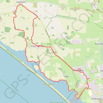
Portesham to Weymouth loop
- Distance: 15.9 mi
- Elevation gain: 1,047 ft
- Maximum elevation: 269 ft
- Elevation loss: 1,043 ft
- Minimum elevation: -7 ft
Interactive trail map
Make a donation
Gear up for your next adventure:
As an Amazon Associate, this site earns from qualifying purchases at no extra cost to you.
Trail profile
- Distance: 15.9 mi
- Elevation gain: 1,047 ft
- Maximum elevation: 269 ft
- Elevation loss: 1,043 ft
- Minimum elevation: -7 ft
Make a donation
Gear up for your next adventure:
As an Amazon Associate, this site earns from qualifying purchases at no extra cost to you.
About this trail
Name: Portesham to Weymouth loop trail, distance, elevation, map, profile, GPS track
Start: Kings Arms, Bramdon Lane, Portesham, Dorset, England, DT3 4LX, United Kingdom (50.66876 -2.56431)
End: Bramdon Lane, Portesham, Dorset, England, DT3 4LX, United Kingdom (50.66869 -2.56365)
Coordinates: 50.60522 -2.57264 50.66937 -2.49201
Make a donation
Gear up for your next adventure:
As an Amazon Associate, this site earns from qualifying purchases at no extra cost to you.
Other hiking, mountain biking, running and outdoor activity trails
Click on a trail to view its statistics, map and profile.
West Bexington to Portisham Loop
United Kingdom > England > Dorset > West Bexington
Distance: 13.3 mi • Elevation gain: 1,155 ft • Maximum elevation: 604 ft
Osmington loop
United Kingdom > England > Dorset > Osmington
West Dorset Road Cycling
Distance: 23.7 mi • Elevation gain: 1,818 ft • Maximum elevation: 686 ft