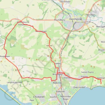
Osmington loop
West Dorset Road Cycling
- Distance: 23.7 mi
- Elevation gain: 1,818 ft
- Maximum elevation: 686 ft
- Elevation loss: 1,821 ft
- Minimum elevation: 36 ft
- Moving time: 1 h 39 m
- Moving speed: 14.3 mph
- Maximum speed: 44.0 mph
- Total time: 1 h 40 m
- Global speed: 14.2 mph
Interactive trail map
Trail profile
- Distance: 23.7 mi
- Elevation gain: 1,818 ft
- Maximum elevation: 686 ft
- Elevation loss: 1,821 ft
- Minimum elevation: 36 ft
- Moving time: 1 h 39 m
- Moving speed: 14.3 mph
- Maximum speed: 44.0 mph
- Total time: 1 h 40 m
- Global speed: 14.2 mph
About this trail
Name: Osmington loop trail, distance, elevation, map, profile, GPS track
Start: Shortlake Farm, Glebe Close, Osmington, Dorset, England, DT3 6EY, United Kingdom (50.63926 -2.39215)
End: Shortlake Farm, Glebe Close, Osmington, Dorset, England, DT3 6EY, United Kingdom (50.63920 -2.39211)
Coordinates: 50.63917 -2.56652 50.71057 -2.39140
Other hiking, mountain biking, running and outdoor activity trails
Click on a trail to view its statistics, map and profile.
West Bexington to Portisham Loop
United Kingdom > England > Dorset > West Bexington
Distance: 13.3 mi • Elevation gain: 1,155 ft • Maximum elevation: 604 ft
Portesham to Weymouth loop
United Kingdom > England > Dorset > Portesham
Distance: 15.9 mi • Elevation gain: 1,047 ft • Maximum elevation: 269 ft