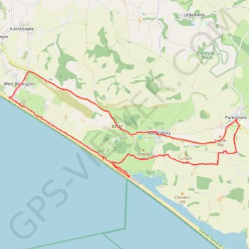
West Bexington to Portisham Loop
- Distance: 13.3 mi
- Elevation gain: 1,155 ft
- Maximum elevation: 604 ft
- Elevation loss: 1,158 ft
- Minimum elevation: 3 ft
- Moving time: 5 h 27 m
- Moving speed: 2.4 mph
- Maximum speed: 3.7 mph
- Total time: 6 h 15 m
- Global speed: 2.1 mph
Interactive trail map
Trail profile
- Distance: 13.3 mi
- Elevation gain: 1,155 ft
- Maximum elevation: 604 ft
- Elevation loss: 1,158 ft
- Minimum elevation: 3 ft
- Moving time: 5 h 27 m
- Moving speed: 2.4 mph
- Maximum speed: 3.7 mph
- Total time: 6 h 15 m
- Global speed: 2.1 mph
About this trail
Name: West Bexington to Portisham Loop trail, distance, elevation, map, profile, GPS track
End: Beach Road, Puncknowle, West Bexington, Dorset, England, DT2 9DG, United Kingdom (50.67585 -2.66537)
Coordinates: 50.65353 -2.66577 50.68354 -2.56285
Other hiking, mountain biking, running and outdoor activity trails
Click on a trail to view its statistics, map and profile.
Loop between West Bay and West Bexington along Lyme Bay
United Kingdom > England > Dorset > Bridport
Distance: 13.7 mi • Elevation gain: 981 ft • Maximum elevation: 420 ft
Portesham to Weymouth loop
United Kingdom > England > Dorset > Portesham
Distance: 15.9 mi • Elevation gain: 1,047 ft • Maximum elevation: 269 ft
Osmington loop
United Kingdom > England > Dorset > Osmington
West Dorset Road Cycling
Distance: 23.7 mi • Elevation gain: 1,818 ft • Maximum elevation: 686 ft