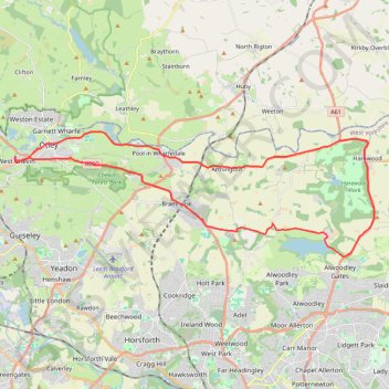
Otley - Eccup Reservoir - Harewood Bank - Otley (bicycle)
- Distance: 21.5 mi
- Elevation gain: 1,194 ft
- Maximum elevation: 584 ft
- Elevation loss: 1,191 ft
- Minimum elevation: 108 ft
- Moving time: 1 h 49 m
- Moving speed: 11.8 mph
- Maximum speed: 29.5 mph
- Total time: 1 h 49 m
- Global speed: 11.8 mph
Interactive trail map
Trail profile
- Distance: 21.5 mi
- Elevation gain: 1,194 ft
- Maximum elevation: 584 ft
- Elevation loss: 1,191 ft
- Minimum elevation: 108 ft
- Moving time: 1 h 49 m
- Moving speed: 11.8 mph
- Maximum speed: 29.5 mph
- Total time: 1 h 49 m
- Global speed: 11.8 mph
About this trail
Name: Otley - Eccup Reservoir - Harewood Bank - Otley (bicycle) trail, distance, elevation, map, profile, GPS track
Coordinates: 53.86736 -1.71330 53.90983 -1.50634
Other hiking, mountain biking, running and outdoor activity trails
Click on a trail to view its statistics, map and profile.
Otley - Draughton/Skipton Moor and return
United Kingdom > England > Leeds
Distance: 25.7 mi • Elevation gain: 1,496 ft • Maximum elevation: 1,043 ft
Otley - Eccup Reservoir - Harewood Bank - Otley (bicycle)
United Kingdom > England > Otley
Distance: 21.7 mi • Elevation gain: 1,237 ft • Maximum elevation: 587 ft
Otley Chevin
United Kingdom > England > Otley
Distance: 5.4 mi • Elevation gain: 781 ft • Maximum elevation: 912 ft