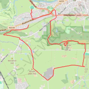
Otley Chevin
- Distance: 5.4 mi
- Elevation gain: 781 ft
- Maximum elevation: 912 ft
- Elevation loss: 823 ft
- Minimum elevation: 197 ft
- Moving time: 2 h 44 m
- Moving speed: 2.0 mph
- Maximum speed: 10.3 mph
- Total time: 4 h 20 m
- Global speed: 1.3 mph
Interactive trail map
Trail profile
- Distance: 5.4 mi
- Elevation gain: 781 ft
- Maximum elevation: 912 ft
- Elevation loss: 823 ft
- Minimum elevation: 197 ft
- Moving time: 2 h 44 m
- Moving speed: 2.0 mph
- Maximum speed: 10.3 mph
- Total time: 4 h 20 m
- Global speed: 1.3 mph
About this trail
Name: Otley Chevin trail, distance, elevation, map, profile, GPS track
Coordinates: 53.88445 -1.72464 53.90206 -1.69017
Other hiking, mountain biking, running and outdoor activity trails
Click on a trail to view its statistics, map and profile.
Otley - Draughton/Skipton Moor and return
United Kingdom > England > Leeds
Distance: 25.7 mi • Elevation gain: 1,496 ft • Maximum elevation: 1,043 ft
Otley - Eccup Reservoir - Harewood Bank - Otley (bicycle)
United Kingdom > England > Otley
Distance: 21.7 mi • Elevation gain: 1,237 ft • Maximum elevation: 587 ft
Otley - Eccup Reservoir - Harewood Bank - Otley (bicycle)
United Kingdom > England > Otley
Distance: 21.5 mi • Elevation gain: 1,194 ft • Maximum elevation: 584 ft