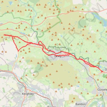
Otley - Draughton/Skipton Moor and return
- Distance: 25.7 mi
- Elevation gain: 1,496 ft
- Maximum elevation: 1,043 ft
- Elevation loss: 1,467 ft
- Minimum elevation: 180 ft
- Moving time: 3 h 6 m
- Moving speed: 8.3 mph
- Maximum speed: 24.0 mph
- Total time: 4 h 14 m
- Global speed: 6.1 mph
Interactive trail map
Trail profile
- Distance: 25.7 mi
- Elevation gain: 1,496 ft
- Maximum elevation: 1,043 ft
- Elevation loss: 1,467 ft
- Minimum elevation: 180 ft
- Moving time: 3 h 6 m
- Moving speed: 8.3 mph
- Maximum speed: 24.0 mph
- Total time: 4 h 14 m
- Global speed: 6.1 mph
About this trail
Name: Otley - Draughton/Skipton Moor and return trail, distance, elevation, map, profile, GPS track
Coordinates: 53.90126 -1.96374 53.95787 -1.70757
Other hiking, mountain biking, running and outdoor activity trails
Click on a trail to view its statistics, map and profile.
Otley - Eccup Reservoir - Harewood Bank - Otley (bicycle)
United Kingdom > England > Otley
Distance: 21.7 mi • Elevation gain: 1,237 ft • Maximum elevation: 587 ft
Otley - Eccup Reservoir - Harewood Bank - Otley (bicycle)
United Kingdom > England > Otley
Distance: 21.5 mi • Elevation gain: 1,194 ft • Maximum elevation: 584 ft
Otley Chevin
United Kingdom > England > Otley
Distance: 5.4 mi • Elevation gain: 781 ft • Maximum elevation: 912 ft
Otley - Farnley - Clifton - Otley (foot)
United Kingdom > England > North Yorkshire > Otley
Distance: 4.7 mi • Elevation gain: 472 ft • Maximum elevation: 686 ft
Burley Woodhead walk (foot)
United Kingdom > England > Bradford > Menston
Menston - Burley Woodhead - Burley - Menston
Distance: 7.5 mi • Elevation gain: 830 ft • Maximum elevation: 981 ft
Trails and canal from Silsden
United Kingdom > England > Bradford > Silsden
Distance: 3.1 mi • Elevation gain: 223 ft • Maximum elevation: 515 ft
White Wells Loop
United Kingdom > England > Bradford > Ilkley
Distance: 3.1 mi • Elevation gain: 755 ft • Maximum elevation: 1,040 ft