Thank you for supporting this site ❤️
Make a donation
Make a donation
Gear up for your next adventure:
As an Amazon Associate, this site earns from qualifying purchases at no extra cost to you.
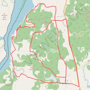
Gravel Bike Vermont
- Distance: 26.9 mi
- Elevation gain: 2,671 ft
- Maximum elevation: 653 ft
- Elevation loss: 2,671 ft
- Minimum elevation: 92 ft
- Moving time: 2 h 48 m
- Moving speed: 9.6 mph
- Maximum speed: 35.9 mph
- Total time: 3 h 10 m
- Global speed: 8.5 mph
Interactive trail map
Thank you for supporting this site ❤️
Make a donation
Make a donation
Gear up for your next adventure:
As an Amazon Associate, this site earns from qualifying purchases at no extra cost to you.
Trail profile
- Distance: 26.9 mi
- Elevation gain: 2,671 ft
- Maximum elevation: 653 ft
- Elevation loss: 2,671 ft
- Minimum elevation: 92 ft
- Moving time: 2 h 48 m
- Moving speed: 9.6 mph
- Maximum speed: 35.9 mph
- Total time: 3 h 10 m
- Global speed: 8.5 mph
Thank you for supporting this site ❤️
Make a donation
Make a donation
Gear up for your next adventure:
As an Amazon Associate, this site earns from qualifying purchases at no extra cost to you.
About this trail
Name: Gravel Bike Vermont trail, distance, elevation, map, profile, GPS track
Coordinates: 43.70429 -73.36733 43.76681 -73.29611
Topography: Rutland County topographic map, elevation, terrain
Thank you for supporting this site ❤️
Make a donation
Make a donation
Gear up for your next adventure:
As an Amazon Associate, this site earns from qualifying purchases at no extra cost to you.
Other hiking, mountain biking, running and outdoor activity trails
Click on a trail to view its statistics, map and profile.