Thank you for supporting this site ❤️
Make a donation
Make a donation
Gear up for your next adventure:
As an Amazon Associate, this site earns from qualifying purchases at no extra cost to you.
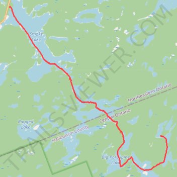
Algonquin Canoe Trip Day 2
- Distance: 11.4 mi
- Elevation gain: 410 ft
- Maximum elevation: 1,611 ft
- Elevation loss: 591 ft
- Minimum elevation: 1,355 ft
- Moving time: 3 h 41 m
- Moving speed: 3.1 mph
- Maximum speed: 5.0 mph
- Total time: 4 h 3 m
- Global speed: 2.8 mph
Interactive trail map
Thank you for supporting this site ❤️
Make a donation
Make a donation
Gear up for your next adventure:
As an Amazon Associate, this site earns from qualifying purchases at no extra cost to you.
Trail profile
- Distance: 11.4 mi
- Elevation gain: 410 ft
- Maximum elevation: 1,611 ft
- Elevation loss: 591 ft
- Minimum elevation: 1,355 ft
- Moving time: 3 h 41 m
- Moving speed: 3.1 mph
- Maximum speed: 5.0 mph
- Total time: 4 h 3 m
- Global speed: 2.8 mph
Thank you for supporting this site ❤️
Make a donation
Make a donation
Gear up for your next adventure:
As an Amazon Associate, this site earns from qualifying purchases at no extra cost to you.
About this trail
Name: Algonquin Canoe Trip Day 2 trail, distance, elevation, map, profile, GPS track
Coordinates: 45.44667 -78.70211 45.53323 -78.58305
Thank you for supporting this site ❤️
Make a donation
Make a donation
Gear up for your next adventure:
As an Amazon Associate, this site earns from qualifying purchases at no extra cost to you.
Other hiking, mountain biking, running and outdoor activity trails
Click on a trail to view its statistics, map and profile.
Algonquin Canoe Trip Day 1
Canada > Ontario > Nipissing District > Unorganized South Nipissing
Distance: 16.5 mi • Elevation gain: 1,152 ft • Maximum elevation: 1,585 ft