Thank you for supporting this site ❤️
Make a donation
Make a donation
Gear up for your next adventure:
As an Amazon Associate, this site earns from qualifying purchases at no extra cost to you.
Algonquin Canoe Trip Day 1
- Distance: 16.5 mi
- Elevation gain: 1,152 ft
- Maximum elevation: 1,585 ft
- Elevation loss: 951 ft
- Minimum elevation: 1,348 ft
- Moving time: 5 h 25 m
- Moving speed: 3.0 mph
- Maximum speed: 7.7 mph
- Total time: 7 h 4 m
- Global speed: 2.3 mph
Interactive trail map
Thank you for supporting this site ❤️
Make a donation
Make a donation
Gear up for your next adventure:
As an Amazon Associate, this site earns from qualifying purchases at no extra cost to you.
Trail profile
- Distance: 16.5 mi
- Elevation gain: 1,152 ft
- Maximum elevation: 1,585 ft
- Elevation loss: 951 ft
- Minimum elevation: 1,348 ft
- Moving time: 5 h 25 m
- Moving speed: 3.0 mph
- Maximum speed: 7.7 mph
- Total time: 7 h 4 m
- Global speed: 2.3 mph
Thank you for supporting this site ❤️
Make a donation
Make a donation
Gear up for your next adventure:
As an Amazon Associate, this site earns from qualifying purchases at no extra cost to you.
About this trail
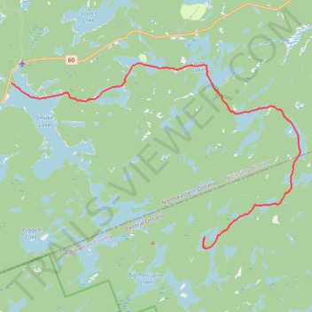
Name: Algonquin Canoe Trip Day 1 trail, distance, elevation, map, profile, GPS track
Coordinates: 45.46464 -78.70151 45.54141 -78.53100
Thank you for supporting this site ❤️
Make a donation
Make a donation
Gear up for your next adventure:
As an Amazon Associate, this site earns from qualifying purchases at no extra cost to you.
Other hiking, mountain biking, running and outdoor activity trails
Click on a trail to view its statistics, map and profile.
Algonquin Canoe Trip Day 2
Canada > Ontario > Haliburton County > Algonquin Highlands
Distance: 11.4 mi • Elevation gain: 410 ft • Maximum elevation: 1,611 ft