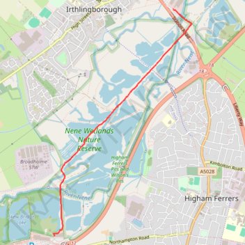
Walk from Irthlingborough to Rushden Lakes in Nene Wetlands Nature Reserve
- Distance: 2.2 mi
- Elevation gain: 46 ft
- Maximum elevation: 141 ft
- Elevation loss: 36 ft
- Minimum elevation: 108 ft
- Moving time: 38 m 45 s
- Moving speed: 3.4 mph
- Maximum speed: 5.2 mph
- Total time: 39 m 51 s
- Global speed: 3.3 mph
Interactive trail map
Trail profile
- Distance: 2.2 mi
- Elevation gain: 46 ft
- Maximum elevation: 141 ft
- Elevation loss: 36 ft
- Minimum elevation: 108 ft
- Moving time: 38 m 45 s
- Moving speed: 3.4 mph
- Maximum speed: 5.2 mph
- Total time: 39 m 51 s
- Global speed: 3.3 mph
About this trail
Name: Walk from Irthlingborough to Rushden Lakes in Nene Wetlands Nature Reserve trail, distance, elevation, map, profile, GPS track
Coordinates: 52.30200 -0.61989 52.32618 -0.59579
Other hiking, mountain biking, running and outdoor activity trails
Click on a trail to view its statistics, map and profile.
42 Km walk around Wellingborough
United Kingdom > England > North Northamptonshire > Wellingborough > Little Irchester
Distance: 25.9 mi • Elevation gain: 1,010 ft • Maximum elevation: 377 ft
The Jo Cox Way 2022 Day 3 Market Bosworth to Milton Keynes
United Kingdom > England > Leicestershire > Hinckley and Bosworth > Market Bosworth
Distance: 76.4 mi • Elevation gain: 3,127 ft • Maximum elevation: 640 ft