Make a donation
Gear up for your next adventure:
As an Amazon Associate, this site earns from qualifying purchases at no extra cost to you.
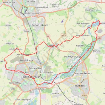
42 Km walk around Wellingborough
- Distance: 25.9 mi
- Elevation gain: 1,010 ft
- Maximum elevation: 377 ft
- Elevation loss: 1,014 ft
- Minimum elevation: 105 ft
- Moving time: 8 h 31 m
- Moving speed: 3.0 mph
- Maximum speed: 5.6 mph
- Total time: 10 h 3 m
- Global speed: 2.6 mph
Interactive trail map
Make a donation
Gear up for your next adventure:
As an Amazon Associate, this site earns from qualifying purchases at no extra cost to you.
Trail profile
- Distance: 25.9 mi
- Elevation gain: 1,010 ft
- Maximum elevation: 377 ft
- Elevation loss: 1,014 ft
- Minimum elevation: 105 ft
- Moving time: 8 h 31 m
- Moving speed: 3.0 mph
- Maximum speed: 5.6 mph
- Total time: 10 h 3 m
- Global speed: 2.6 mph
Make a donation
Gear up for your next adventure:
As an Amazon Associate, this site earns from qualifying purchases at no extra cost to you.
About this trail
Name: 42 Km walk around Wellingborough trail, distance, elevation, map, profile, GPS track
Coordinates: 52.29186 -0.74779 52.36967 -0.55718
Make a donation
Gear up for your next adventure:
As an Amazon Associate, this site earns from qualifying purchases at no extra cost to you.
Other hiking, mountain biking, running and outdoor activity trails
Click on a trail to view its statistics, map and profile.
Loop walk along River Nene around Chester House area
United Kingdom > England > North Northamptonshire > Little Irchester
Distance: 1.1 mi • Elevation gain: 26 ft • Maximum elevation: 154 ft
Wellingborough Waendel Walk walk
United Kingdom > England > North Northamptonshire > Wellingborough > Little Irchester
Distance: 10.1 mi • Elevation gain: 463 ft • Maximum elevation: 335 ft
Walk from Irthlingborough to Rushden Lakes in Nene Wetlands Nature Reserve
United Kingdom > England > North Northamptonshire > Wellingborough
Distance: 2.2 mi • Elevation gain: 46 ft • Maximum elevation: 141 ft
Walking from Kettering to Northampton via various PRoW paths
United Kingdom > England > North Northamptonshire > Kettering
Distance: 17.1 mi • Elevation gain: 876 ft • Maximum elevation: 384 ft
Make a donation
Gear up for your next adventure:
As an Amazon Associate, this site earns from qualifying purchases at no extra cost to you.
The Jo Cox Way 2022 Day 3 Market Bosworth to Milton Keynes
United Kingdom > England > Leicestershire > Hinckley and Bosworth > Market Bosworth
Distance: 76.4 mi • Elevation gain: 3,127 ft • Maximum elevation: 640 ft
Isham Footpath
United Kingdom > England > North Northamptonshire > Kettering
Evening Run
Distance: 6.3 mi • Elevation gain: 364 ft • Maximum elevation: 282 ft