Flitwick
- Distance: 10.3 mi
- Elevation gain: 466 ft
- Maximum elevation: 364 ft
- Elevation loss: 466 ft
- Minimum elevation: 190 ft
- Moving time: 3 h 56 m
- Moving speed: 2.6 mph
- Maximum speed: 4.5 mph
- Total time: 6 h 28 m
- Global speed: 1.6 mph
Interactive trail map
Trail profile
- Distance: 10.3 mi
- Elevation gain: 466 ft
- Maximum elevation: 364 ft
- Elevation loss: 466 ft
- Minimum elevation: 190 ft
- Moving time: 3 h 56 m
- Moving speed: 2.6 mph
- Maximum speed: 4.5 mph
- Total time: 6 h 28 m
- Global speed: 1.6 mph
About this trail
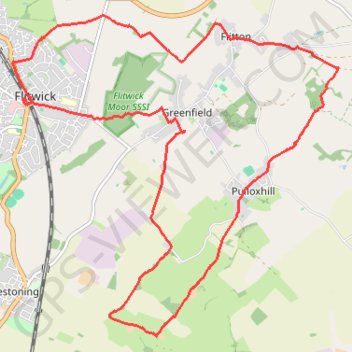
Name: Flitwick trail, distance, elevation, map, profile, GPS track
Coordinates: 51.97707 -0.49782 52.01345 -0.43802
Other hiking, mountain biking, running and outdoor activity trails
Click on a trail to view its statistics, map and profile.
The Jo Cox Way 2022 Day 4 - Milton Keynes to Uxbridge
United Kingdom > England > City of Milton Keynes > Milton Keynes > Monkston
Distance: 64.9 mi • Elevation gain: 3,406 ft • Maximum elevation: 823 ft
The JCW 23 - Cranfield to Uxbridge
United Kingdom > England > Central Bedfordshire > Cranfield
Distance: 56.0 mi • Elevation gain: 2,831 ft • Maximum elevation: 873 ft
Route
United Kingdom > England > Central Bedfordshire > Upper Sundon
Distance: 70.2 mi • Elevation gain: 2,963 ft • Maximum elevation: 558 ft