The Jo Cox Way 2022 Day 4 - Milton Keynes to Uxbridge
- Distance: 64.9 mi
- Elevation gain: 3,406 ft
- Maximum elevation: 823 ft
- Elevation loss: 3,533 ft
- Minimum elevation: 105 ft
- Moving time: 4 h 54 m
- Moving speed: 13.2 mph
- Maximum speed: 38.5 mph
- Total time: 4 h 54 m
- Global speed: 13.2 mph
Interactive trail map
Trail profile
- Distance: 64.9 mi
- Elevation gain: 3,406 ft
- Maximum elevation: 823 ft
- Elevation loss: 3,533 ft
- Minimum elevation: 105 ft
- Moving time: 4 h 54 m
- Moving speed: 13.2 mph
- Maximum speed: 38.5 mph
- Total time: 4 h 54 m
- Global speed: 13.2 mph
About this trail
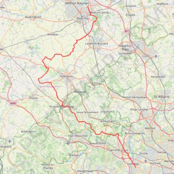
Name: The Jo Cox Way 2022 Day 4 - Milton Keynes to Uxbridge trail, distance, elevation, map, profile, GPS track
Coordinates: 51.53298 -0.95344 52.02957 -0.46754
Other hiking, mountain biking, running and outdoor activity trails
Click on a trail to view its statistics, map and profile.
The Rye
United Kingdom > England > Buckinghamshire > High Wycombe
Distance: 1.0 mi • Elevation gain: 75 ft • Maximum elevation: 256 ft
Bike ride Haddenham - Cuddington - Chearsley including The Maltings, Haddenham
United Kingdom > England > Buckinghamshire > Haddenham
Distance: 8.6 mi • Elevation gain: 436 ft • Maximum elevation: 413 ft
The Jo Cox Way 2022 Day 3 Market Bosworth to Milton Keynes
United Kingdom > England > Leicestershire > Hinckley and Bosworth > Market Bosworth
Distance: 76.4 mi • Elevation gain: 3,127 ft • Maximum elevation: 640 ft
Run around Downley, Disraeli and Hughenden
United Kingdom > England > Buckinghamshire > Downley
Wycombe Trail Running
Distance: 6.2 mi • Elevation gain: 682 ft • Maximum elevation: 607 ft
NW High Wycombe, Downley, Hughenden Park
United Kingdom > England > Buckinghamshire > High Wycombe
Distance: 5.8 mi • Elevation gain: 751 ft • Maximum elevation: 561 ft
The JCW 23 - Cranfield to Uxbridge
United Kingdom > England > Central Bedfordshire > Cranfield
Distance: 56.0 mi • Elevation gain: 2,831 ft • Maximum elevation: 873 ft
Coombe Hill from Wendover
United Kingdom > England > Buckinghamshire > Wendover
Distance: 4.1 mi • Elevation gain: 479 ft • Maximum elevation: 856 ft
New path at top of Berryfields
United Kingdom > England > Buckinghamshire
Distance: 4.8 mi • Elevation gain: 125 ft • Maximum elevation: 276 ft
Dockey Woods
United Kingdom > England > Buckinghamshire > Ivinghoe
Distance: 6.0 mi • Elevation gain: 492 ft • Maximum elevation: 823 ft
Twyford to Hurley loop
United Kingdom > England > Borough of Wokingham > Twyford
Distance: 15.7 mi • Elevation gain: 1,112 ft • Maximum elevation: 469 ft
Coombe Hill Loop Trail
United Kingdom > England > Buckinghamshire > Wendover
Distance: 5.7 mi • Elevation gain: 617 ft • Maximum elevation: 843 ft
Kingsbook loop run
United Kingdom > England > Buckinghamshire > Aylesbury
Afternoon Run
Distance: 6.1 mi • Elevation gain: 118 ft • Maximum elevation: 308 ft
Ivinghoe Beacon
United Kingdom > England > Buckinghamshire > Dacorum
Distance: 5.1 mi • Elevation gain: 486 ft • Maximum elevation: 823 ft
JCW25 Day 4
United Kingdom > England > Central Bedfordshire > Cranfield
Distance: 65.8 mi • Elevation gain: 3,166 ft • Maximum elevation: 873 ft
Flitwick
United Kingdom > England > Central Bedfordshire > Flitwick
Distance: 10.3 mi • Elevation gain: 466 ft • Maximum elevation: 364 ft
Route
United Kingdom > England > Central Bedfordshire > Upper Sundon
Distance: 70.2 mi • Elevation gain: 2,963 ft • Maximum elevation: 558 ft