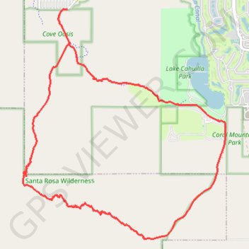
Boo Hoff Trail Loop
Interactive trail map
Trail profile
- Distance: 12.4 mi
- Elevation gain: 2,336 ft
- Maximum elevation: 1,893 ft
- Elevation loss: 2,336 ft
- Minimum elevation: 13 ft
About this trail
Name: Boo Hoff Trail Loop trail, distance, elevation, map, profile, GPS track
Start: Calle Tecate, La Quinta, Riverside County, California, 92253, United States (33.64883 -116.30993)
Coordinates: 33.59826 -116.32172 33.64883 -116.26815
Topography: Riverside County topographic map, elevation, terrain
Other hiking, mountain biking, running and outdoor activity trails
Click on a trail to view its statistics, map and profile.