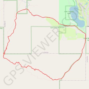
Lake Cahuilla to Cove Oasis Loop
Loop hike from Lake Cahuilla Park to Cove Oasis via Boo Hoff Trail in the Santa Rosa Wilderness. #Hiking #Loop #Lake #Nature #Mountain #Wilderness #Desert
- Distance: 10.8 mi
- Elevation gain: 2,208 ft
- Maximum elevation: 1,893 ft
- Elevation loss: 2,208 ft
- Minimum elevation: 3 ft
- Moving time: 4 h 7 m
- Moving speed: 2.6 mph
- Maximum speed: 5.2 mph
- Total time: 4 h 29 m
- Global speed: 2.4 mph
Interactive trail map
Trail profile
- Distance: 10.8 mi
- Elevation gain: 2,208 ft
- Maximum elevation: 1,893 ft
- Elevation loss: 2,208 ft
- Minimum elevation: 3 ft
- Moving time: 4 h 7 m
- Moving speed: 2.6 mph
- Maximum speed: 5.2 mph
- Total time: 4 h 29 m
- Global speed: 2.4 mph
About this trail
Name: Lake Cahuilla to Cove Oasis Loop trail, distance, elevation, map, profile, GPS track
Start: Quarry Lane, La Quinta, Riverside County, California, 92247, United States (33.62440 -116.27002)
End: Quarry Lane, La Quinta, Riverside County, California, 92247, United States (33.62441 -116.27002)
Coordinates: 33.59829 -116.32173 33.63690 -116.26808
Topography: Riverside County topographic map, elevation, terrain
Other hiking, mountain biking, running and outdoor activity trails
Click on a trail to view its statistics, map and profile.