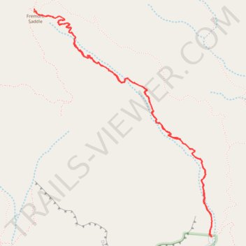
Fremont Saddle
Via Peralta Canyon Trail in Superstition Wilderness #Hike #Mountain #Forest #Rock #Overlook
- Distance: 4.5 mi
- Elevation gain: 1,371 ft
- Maximum elevation: 3,770 ft
- Elevation loss: 1,371 ft
- Minimum elevation: 2,415 ft
- Moving time: 2 h 28 m
- Moving speed: 1.8 mph
- Maximum speed: 4.1 mph
- Total time: 2 h 48 m
- Global speed: 1.6 mph
Interactive trail map
Trail profile
About this trail
Name: Fremont Saddle trail, distance, elevation, map, profile, GPS track
Start: Peralta Canyon Trail, Pinal County, Arizona, United States (33.39765 -111.34787)
End: Dutchman Trail #104, Pinal County, Arizona, United States (33.39764 -111.34785)
Coordinates: 33.39764 -111.36491 33.41595 -111.34781
Topography: Pinal County topographic map, elevation, terrain
Other hiking, mountain biking, running and outdoor activity trails
Click on a trail to view its statistics, map and profile.
Wave Cave Trail in Superstition Wilderness
United States > Arizona > Pinal County
The Wave Cave Trail in Arizona's Superstition Mountains offers hikers a journey through a landscape adorned with towering saguaro cacti, prickly pear, and mesquite trees. The trail leads to a captivating cave featuring a distinctive rock formation resembling a wave, providing a unique photo opportunity. From…
Distance: 3.1 mi • Elevation gain: 958 ft • Maximum elevation: 3,166 ft
Fremont Saddle via Peralta Canyon Trail in Superstition Wilderness
United States > Arizona > Pinal County
The Peralta Trail to Fremont Saddle offers a rewarding hike through Arizona's Superstition Mountains, culminating in a panoramic view of the iconic Weavers Needle. As you ascend, the trail winds through diverse desert flora, including oak and mesquite trees, with rugged volcanic rock formations towering above.…
Distance: 4.5 mi • Elevation gain: 1,355 ft • Maximum elevation: 3,773 ft
Fremont Saddle and Weaver's Needle Loop via Peralta Canyon Trail and Cave Trail
United States > Arizona > Pinal County
This loop offers an excellent combination of rugged desert beauty and rewarding vistas. As you ascend the Peralta Canyon Trail, the trail weaves through a vibrant Sonoran Desert landscape, featuring towering saguaro cacti and jagged rock pinnacles. Once reaching Fremont Saddle, hikers are treated to a…
Distance: 5.4 mi • Elevation gain: 1,637 ft • Maximum elevation: 3,812 ft