Eagle Lake
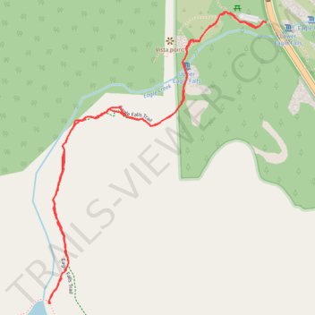
Interactive trail map
Trail profile
- Distance: 2.0 mi
- Elevation gain: 489 ft
- Maximum elevation: 7,021 ft
- Elevation loss: 489 ft
- Minimum elevation: 6,575 ft
- Moving time: 1 h 6 m
- Moving speed: 1.8 mph
- Maximum speed: 3.4 mph
- Total time: 1 h 8 m
- Global speed: 1.7 mph
About this trail
Name: Eagle Lake trail, distance, elevation, map, profile, GPS track
Start: Emerald Bay Road, El Dorado County, California, United States (38.95177 -120.11226)
End: Emerald Bay Road, El Dorado County, California, United States (38.95177 -120.11227)
Coordinates: 38.94363 -120.12038 38.95208 -120.11226
Topography: El Dorado County topographic map, elevation, terrain
Other hiking, mountain biking, running and outdoor activity trails
Click on a trail to view its statistics, map and profile.
Eagle Lake Trail in Desolation Wilderness
United States > California > El Dorado County
The Eagle Lake Trail in California's Desolation Wilderness offers a moderately challenging hike through a picturesque landscape of towering pines, granite peaks, and cascading waterfalls. Starting near Emerald Bay, the trail ascends past the scenic Eagle Falls before reaching the serene Eagle Lake, nestled…
Distance: 1.9 mi • Elevation gain: 456 ft • Maximum elevation: 7,021 ft