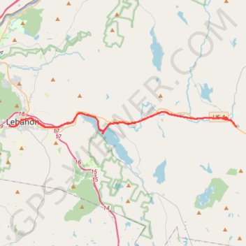
Northern Rail Trail: Lebanon - Mud Pond/Canaan
- Distance: 31.3 mi
- Elevation gain: 1,778 ft
- Maximum elevation: 974 ft
- Elevation loss: 1,778 ft
- Minimum elevation: 525 ft
- Moving time: 2 h 51 m
- Moving speed: 11.0 mph
- Maximum speed: 17.1 mph
- Total time: 2 h 59 m
- Global speed: 10.5 mph
Interactive trail map
Trail profile
- Distance: 31.3 mi
- Elevation gain: 1,778 ft
- Maximum elevation: 974 ft
- Elevation loss: 1,778 ft
- Minimum elevation: 525 ft
- Moving time: 2 h 51 m
- Moving speed: 11.0 mph
- Maximum speed: 17.1 mph
- Total time: 2 h 59 m
- Global speed: 10.5 mph
About this trail
Name: Northern Rail Trail: Lebanon - Mud Pond/Canaan trail, distance, elevation, map, profile, GPS track
Coordinates: 43.63240 -72.26708 43.65116 -71.99854
Topography: Grafton County topographic map, elevation, terrain
Other hiking, mountain biking, running and outdoor activity trails
Click on a trail to view its statistics, map and profile.
Crystal Lake Trail
United States > New Hampshire > Grafton County > Enfield
Distance: 13.9 mi • Elevation gain: 1,171 ft • Maximum elevation: 1,132 ft