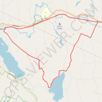
Crystal Lake Trail
- Distance: 13.9 mi
- Elevation gain: 1,171 ft
- Maximum elevation: 1,132 ft
- Elevation loss: 1,165 ft
- Minimum elevation: 774 ft
- Moving time: 1 h 7 m
- Moving speed: 12.4 mph
- Maximum speed: 31.5 mph
- Total time: 1 h 10 m
- Global speed: 11.9 mph
Interactive trail map
Trail profile
- Distance: 13.9 mi
- Elevation gain: 1,171 ft
- Maximum elevation: 1,132 ft
- Elevation loss: 1,165 ft
- Minimum elevation: 774 ft
- Moving time: 1 h 7 m
- Moving speed: 12.4 mph
- Maximum speed: 31.5 mph
- Total time: 1 h 10 m
- Global speed: 11.9 mph
About this trail
Name: Crystal Lake Trail trail, distance, elevation, map, profile, GPS track
Start: 97, Union Street, Enfield, Grafton County, New Hampshire, 03748, United States (43.64132 -72.14016)
End: 74, Union Street, Enfield, Grafton County, New Hampshire, 03748, United States (43.64094 -72.14091)
Coordinates: 43.59924 -72.14139 43.65113 -72.04947
Topography: Grafton County topographic map, elevation, terrain
Other hiking, mountain biking, running and outdoor activity trails
Click on a trail to view its statistics, map and profile.
Smith Pond Shaker Forest Loop
United States > New Hampshire > Grafton County > Enfield > Montcalm
Distance: 5.6 mi • Elevation gain: 1,083 ft • Maximum elevation: 1,713 ft
Northern Rail Trail: Lebanon - Mud Pond/Canaan
United States > New Hampshire > Grafton County > Canaan > Graceville
Distance: 31.3 mi • Elevation gain: 1,778 ft • Maximum elevation: 974 ft
Suky Marsh Trail
United States > New Hampshire > Grafton County > Enfield
Afternoon Hike
Distance: 1.5 mi • Elevation gain: 174 ft • Maximum elevation: 991 ft