Make a donation
Gear up for your next adventure:
As an Amazon Associate, this site earns from qualifying purchases at no extra cost to you.
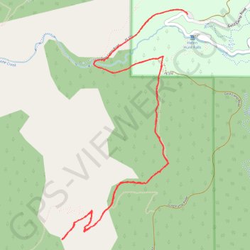
St. Mary's Falls Trail in Pike National Forest
The St. Mary’s Falls Trail in Pike National Forest offers a rewarding hike through North Cheyenne Canyon. Beginning on a closed section of Gold Camp Road, the route passes through a mix of aspen and pine forests, offering views of small waterfalls and a flowing creek along the way. The final stretch involves steeper switchbacks, culminating in a serene setting at St. Mary’s Falls, where the cascading water over granite cliffs provides a refreshing and scenic endpoint. #Hiking #Mountain #Forest #Nature #Waterfall
- Distance: 6.5 mi
- Elevation gain: 1,512 ft
- Maximum elevation: 8,924 ft
- Elevation loss: 1,516 ft
- Minimum elevation: 7,520 ft
- Moving time: 3 h 21 m
- Moving speed: 1.9 mph
- Maximum speed: 7.7 mph
- Total time: 5 h 3 m
- Global speed: 1.3 mph
Interactive trail map
Make a donation
Gear up for your next adventure:
As an Amazon Associate, this site earns from qualifying purchases at no extra cost to you.
Trail profile
- Distance: 6.5 mi
- Elevation gain: 1,512 ft
- Maximum elevation: 8,924 ft
- Elevation loss: 1,516 ft
- Minimum elevation: 7,520 ft
- Moving time: 3 h 21 m
- Moving speed: 1.9 mph
- Maximum speed: 7.7 mph
- Total time: 5 h 3 m
- Global speed: 1.3 mph
Make a donation
Gear up for your next adventure:
As an Amazon Associate, this site earns from qualifying purchases at no extra cost to you.
About this trail
Name: St. Mary's Falls Trail in Pike National Forest trail, distance, elevation, map, profile, GPS track
Start: North Cheyenne Canyon Road, El Paso County, Colorado, United States (38.79091 -104.90417)
End: North Cheyenne Canyon Road, El Paso County, Colorado, United States (38.79079 -104.90413)
Coordinates: 38.77094 -104.91827 38.79123 -104.90408
Topography: El Paso County topographic map, elevation, terrain
Make a donation
Gear up for your next adventure:
As an Amazon Associate, this site earns from qualifying purchases at no extra cost to you.
Other hiking, mountain biking, running and outdoor activity trails
Click on a trail to view its statistics, map and profile.
Kineo Mountain Trail, Upper Bear Creek and Seven Bridges loop hike
United States > Colorado > El Paso County
Distance: 7.2 mi • Elevation gain: 1,867 ft • Maximum elevation: 9,085 ft