Make a donation
Gear up for your next adventure:
As an Amazon Associate, this site earns from qualifying purchases at no extra cost to you.
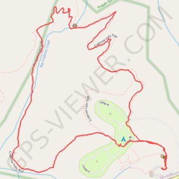
Crabtree Falls Loop Trail in Pisgah National Forest
The Crabtree Falls Loop Trail, situated along the Blue Ridge Parkway in North Carolina, offers hikers a journey through a lush hardwood forest, leading to the base of a picturesque 70-foot cascade. Along the trail, one can observe diverse flora, including wildflowers in early summer and ferns near the waterfall's spray. The trail features a series of well-maintained steps and handrails, particularly in steeper sections, ensuring safety and ease of navigation. #Hiking #Waterfall #Forest #Nature
- Distance: 2.8 mi
- Elevation gain: 525 ft
- Maximum elevation: 3,766 ft
- Elevation loss: 528 ft
- Minimum elevation: 3,327 ft
- Moving time: 1 h 15 m
- Moving speed: 2.2 mph
- Maximum speed: 4.7 mph
- Total time: 1 h 37 m
- Global speed: 1.7 mph
Interactive trail map
Make a donation
Gear up for your next adventure:
As an Amazon Associate, this site earns from qualifying purchases at no extra cost to you.
Trail profile
- Distance: 2.8 mi
- Elevation gain: 525 ft
- Maximum elevation: 3,766 ft
- Elevation loss: 528 ft
- Minimum elevation: 3,327 ft
- Moving time: 1 h 15 m
- Moving speed: 2.2 mph
- Maximum speed: 4.7 mph
- Total time: 1 h 37 m
- Global speed: 1.7 mph
Make a donation
Gear up for your next adventure:
As an Amazon Associate, this site earns from qualifying purchases at no extra cost to you.
About this trail
Name: Crabtree Falls Loop Trail in Pisgah National Forest trail, distance, elevation, map, profile, GPS track
Start: Blue Ridge Parkway, Yancey County, North Carolina, United States (35.81268 -82.14351)
End: Blue Ridge Parkway, Yancey County, North Carolina, United States (35.81267 -82.14356)
Coordinates: 35.81246 -82.15290 35.82086 -82.14323
Topography: Yancey County topographic map, elevation, terrain
Make a donation
Gear up for your next adventure:
As an Amazon Associate, this site earns from qualifying purchases at no extra cost to you.
Other hiking, mountain biking, running and outdoor activity trails
Click on a trail to view its statistics, map and profile.
Crabtree Falls Loop Trail in Blue Ridge Parkway
United States > North Carolina > Yancey County
The Crabtree Falls Loop Trail offers a beautiful and moderately challenging hike. As you descend through a lush oak-hickory forest, you'll pass over rocky sections, switchbacks, and a series of stone steps, all of which make the journey to the falls both scenic and rewarding. At the base, the waterfall…
Distance: 2.8 mi • Elevation gain: 528 ft • Maximum elevation: 3,766 ft
Comfort Suites Airport - Shady Valley Country Store
United States > Tennessee > Blount County > Alcoa > Farrport
146 mi, 2:28
Distance: 146.3 mi • Elevation gain: 10,801 ft • Maximum elevation: 3,428 ft